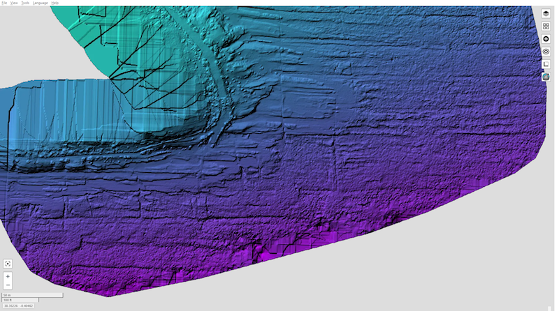
Huerta Cape is an urban rocky coast with coves on the city of Alicante coast (SE Spain), between the San Juan beach to the North and the Albufereta beach to the West. This microtidal coast has a 30-cm tidal amplitude. The basement is made of latest Tortonian 20º- north dipping sandstones covered by flat-laying Tyrrhenian beach microconglomerate with Tethystrombus latus and other Senegalese fauna (MIS 5e, about 120 ka). About 25 UAV (Unmanned Aerial Vehicle)/drone flights have been made on the south Alicante beaches at different flight heights and times of the day, always with appropriate weather conditions, near no-waves flat sea surface, to obtain the best adjustment of sunlight reflection to avoid sunglint and capture the best view of the sea bottom. The flights were designed with the application Dronelink for fast and reproducible flights. The best result was in the wintertime, middle of the morning, and 40 -m-high flights, producing a set of 11 good quality drone flights, a total of 3435 azimuthal photographs were taken. Each flight was processed separately using different photogrammetric software with variable settings to find the best procedure. The best individual 3D models were obtained with the WebODM software. Then flights were grouped in two sets, one with 4 flights corresponding to 1239 valid pictures, and the other 7 flights with 2002 valid pictures. The two 3D models show 2 underwater erosion platforms plus today’s forming vermetid -rimmed platform. It can also be mapped in many blocks, some underwater and others in the foreshore. The fractures could be followed underwater to a depth of about 5 m and the Tyrrhenian level beach microconglomerate could be mapped underwater. Finally, the underwater rocky bottom outcrops are found aligned, producing sandy bottom bands in the slightly eroded levels, whereas bands of Posidonia oceanica could be clearly distinguished in the rocky elevations. This methodology makes it fast and easy to monitor the coastal dynamics until the 3 to 5 m depth where the side scan sonar surveys fail or decrease the quality of the data.
Cite as: Tent-Manclús, J. E. y Bonomo, D. (2025). Using an UAV/drone to map underwater rocky coast (Huerta Cape, Alicante, SE Spain). In: Morales, J. A., Carro, B. M., Cantero, C. y Amador-Luna, D. (Eds.). Sedimentology on the estuary shore 38th IAS Meeting Huelva-Spain, 26-28 June 2025. 304.
Tags: Alicante, erosion platform, Rocky Coast