Home » 2024
Yearly Archives: 2024
3D modeling of the stratigraphic and structural architecture of the Crotone basin (southern Italiy) using machie learning with Python
The 3D modeling and representation of geological data have experienced significant growth within last years, due to the use of new technologies derived from advancements in land representation methods. These technologies enable interactive, intuitive and clear geological visualizations. This paper shows how, by using the open-source Python software (operable with a simple internet browser) for machine learning (linear and KNN interpolations), together with Geographic Information Systems (GIS), it is possible to achieve interactive 3D visualizations of geological features in sedimentary basins. This study is performed in the onshore-offshore Crotone area (southern Italy) where a large amount of stratigraphic datasets are available from core perforation and seismic profiles due to the presence of a natural gas extraction field. Thanks to a database of 63 drilling lithologic records and 43 check points obtained from 9 interpreted seismic sections, several 3D HTML models were constructed defining three stratigraphic units (Pre-Messinian, Messinian, and Post-Messinian). An overlap of the Post-Messinian top surface and an erosional truncation of the Messinian top surface toward the N were observed, together with a rising of the Pre-Messinian top surface in the northwestern area. This stratigraphic architecture may indicate differential subsidence and/or uplifting due to syn-sedimentary fault kinematics in the whole studied area. The 3D models with the stratigraphic unit boundary surfaces obtained with KNN interpolation (showing stepped and abrupt edges) allowed the interpretation in terms of structural architecture and synsedimentary fault kinematics. Three main sets of faults were deduced: N–S; NNW-SSE, and ENE-WSW. A minorly represented E-W set was added to the main sets. These faults generated a horsts-grabens structure, and in many cases a determinate set of faults caused a progressive lowering or rising of some areas with an “en echelon” arrangement. According to previous works, these deduced sets of faults (most of them strike-slip faults) have a good agreement with the general structural architecture and defined faults in the area.
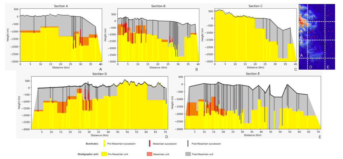
Cite as: Falsetta, E., Bullejos, M., Critelli, S. and Martín-Martín M. (2024). 3D modeling of the stratigraphic and structural architecture of the Crotone basin (southern Italy) using machine learning with Python. Marine and Petroleum Geology 164 (2024) 106825. https://doi.org/10.1016/j.marpetgeo.2024.106825
3D Visualization of geological structures using Python: the case study of the Palomeque sheets
The goal of this paper is the construction of computerized 3D visualization of geological structures. Several Python applications have been used to adapt the paper map-based geological classical information to numerical geological maps represented in HTML files. The models include a map with the stratigraphic and structural contacts and symbols, five serial vertical sections, and a geological block diagram, all with real topography. This block diagram made with 2D figures allows a 3D visualization. Palomeque area (Murcia region, southeastern Spain) has been used as a key-case. This area consists of a deformed Upper Cretaceous to Oligocene succession belonging to the Internal Zone Malaguide Complex. The main structure consists of two thrust-fold sheets forming an imbricate system, also affected by a set of strike-slip faults with a sinistral regime. The constructed maps show a good agreement with the published classical geological maps and cross-sections demonstrating the benefits of using these Python applications.
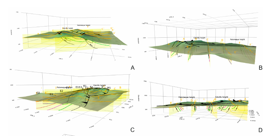
Cite as: Bullejos, M. and Martín-Martín, M. (2023): 3D Visualization of geological structures using Python: the case study of the Palomeque sheets (SE, Spain). Journal of Maps 19, NO. 1, 2282593 https://doi.org/10.1080/17445647.2023.2282593
Field trip in Morocco: Searching for the Nummulites
The Africa call…
Well the third field work campaign the project. This time in the Middle Atlas of Morocco. The objetive was to find Nummulites as the ones in the Betic or in the Rif.
The picture shows the members of the team. Picture taken by Soufian Maaté.
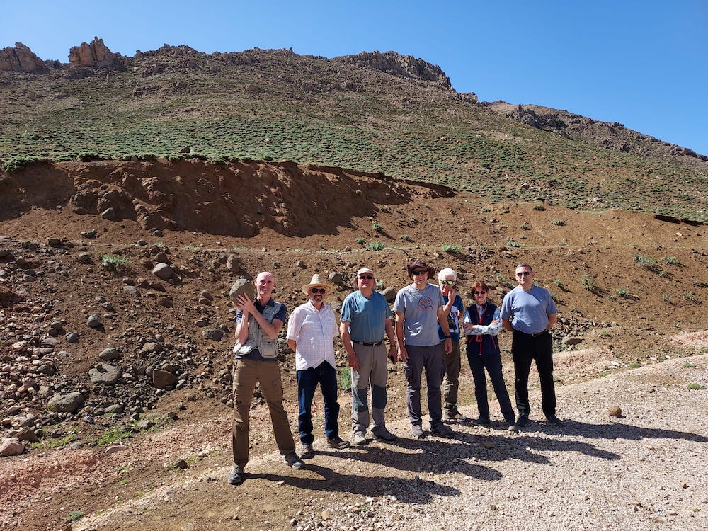
Manuel Bullejos Lorenzo (Granada University)
Rachid Hlila (Abdelmalek Essaádi University)
Ali Maaté (Abdelmalek Essaádi University)
Manuel Martín-Martín (Alicante University)
Soufian Maaté (Moulay Ismail Errachidia University)
Crina Miclăuș (Alexandru Ioan Cuza University)
José Enrique Tent-Manclús (Alicante University)
And the collaborators:
Pedro Robles (Alicante University)
Santiago Moliner (Alicante University).
After a week (from April 23rd until April 30 2023). Many rock samples were taken and we did not find them but our hope is to look carefully the thin sections for tiny Nummulites.
This is the third major field trip of the project of the Spanish research agency (Agencia Estatal de Investigación) of the Spanish Science and innovation minister (Ministerio de Ciencia e Innovación) entitle as “EVOLUCION TECTONO-DEPOSICIONAL DE CUENCAS SEDIMENTARIAS CENOZOICAS: CARACTERIZACION 2D-3D Y MEJORA DE PATRONES ESTANDAR” (PID2020-114381GB-I00). See previous post.
Small scale RT cycles in Prebetic Lower-Middle Eocene (Alicante)
In the study of the Alicante External Prebetic Eocene platforms, ten sedimentary facies were defined in field based on lithology and fossil content observed, as follows: L1 – limestone (lmst.) with Alveolina; L2 – lmst. with small Nummulites (< 3 cm diameter); L3 – lmst. with big Nummulites (>3 cm diameter); L4 – algal lmst.; L5 – lmst. with miliolids; L6 – micritic lmst. with gastropods and bivalves; L7 – marls; L8 – greenish siltstones; L9 – dolomitized lmst. and/or dolostone; L10 – sandy lmst.
The lower interval of the Ibi section twelve L2-L1 units were defined, after which the first dolomitized limestone (L9) occurs, changing the motif to L2-L1-L9 or L1-L9. The middle part of the succession is marked by the occurrence of facies L10, while the upper part by five units with L5-L7.
The lower interval of the Ibi section, consists of thinning-upward units, each one showing a shallowing-upward trend, indicating a decrease of accommodation in middle ramp area, ended with the basinward shift of the proximal open inner ramp. The upper interval, consisting in thickening-upward units, sedimented in lagoon-shoals of inner ramp, indicates increasing of accommodation. This interval is preceded by a period of siliciclastic supply (L10). Consequently, at the scale of the entire outcrop a regressive sequence can be defined with at least 12 smaller RT (Regressive-transgressive) cycles, the lower 6 developed in middle ramp environments, while the upper 6 in inner ramp.
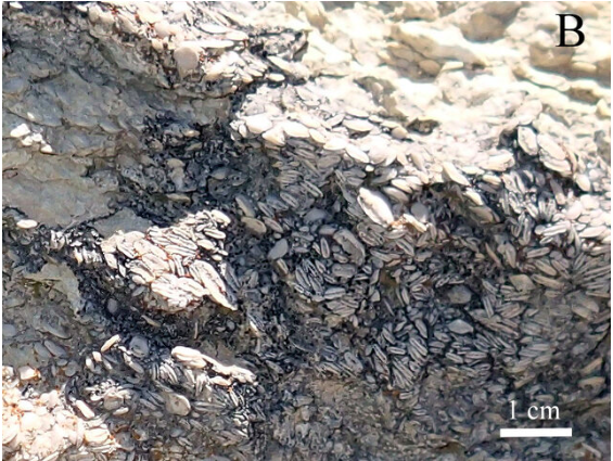
The Prebetic Paleocene-Eocene stratigraphic succession shows a general regressive-transgressive trend. The above-presented results indicate that on the regressive interval of this trend smaller scale RT cycles are superposed.
Cite as: Miclăuș, C., Martín-Martín, M., Tosquella, J., Samsó, J.M. and Tent-Manclús, J.E. (2023): Small scale RT cycles in Lower-Middle Eocene limestones of External Prebetic Units of Betic Cordillera (Alicante Zone). Abstract Book, Fourteenth Romanian Symposium on Palaeontology, Bucharest, 14-15 September 2023 / Zoltán Csiki-Sava, Alina Floroiu, Maria-Raluca Văcărescu, Iuliana Lazăr – Bucureşti : Editura Universităţii din Bucureşti -Bucharest University Press, 2023, 83-84 p.
Recent Comments