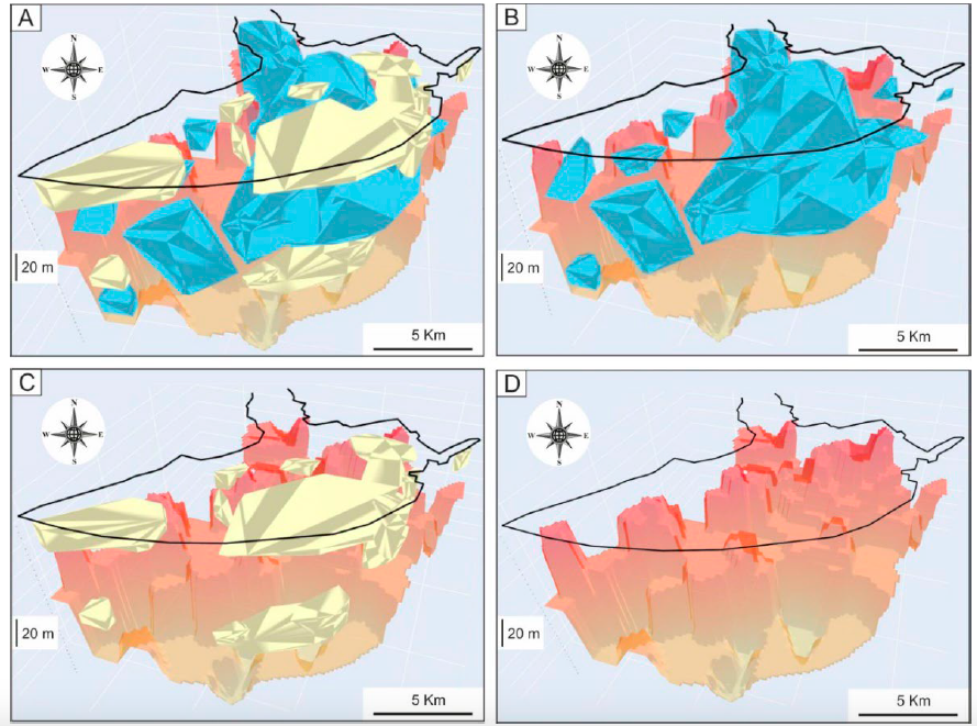
K-nearest neighbors algorithm used for classifying geological variables.
The k-nearest neighbors (KNN) algorithm is a non-parametric supervised machine learning classifier; which uses proximity and similarity to make classifications or predictions about the grouping of an individual data point. This ability makes the KNN algorithm ideal for classifying datasets of geological variables and parameters prior to 3D visualization. This paper introduces a machine learning KNN algorithm and Python libraries for visualizing the 3D stratigraphic architecture of sedimentary porous media in the Quaternary onshore Llobregat River Delta (LRD) in northeastern Spain. A first HTML model showed a consecutive 5 m-equispaced set of horizontal sections of the granulometry classes created with the KNN algorithm from 0 to 120 m below sea level in the onshore LRD. A second HTML model showed the 3D mapping of the main Quaternary gravel and coarse sand sedimentary bodies (lithosomes) and the basement (Pliocene and older rocks) top surface created with Python libraries. These results reproduce well the complex sedimentary structure of the LRD reported in recent scientific publications and proves the suitability of the KNN algorithm and Python libraries for visualizing the 3D stratigraphic structure of sedimentary porous media, which is a crucial stage in making decisions in different environmental and economic geology disciplines.

Interactive figures here
Santiago Moliner Aznar Ph D. Thesis
Santiago Moliner Aznar defended the Ph. D. Thesis “Caracterización y valorización del patrimonio geológico del área de Sierra Espuña (Cordillera Bética: SE, España” on April 27th 2022.

Abstract:
The Sierra Espuña area (Murcia: SE Spain) is characterized by their great biodiversity integrated in the Intercontinental Biosphere Reserve of the Mediterranean. Although authorities are very interested in valorization and protection of biodiversity (flora and fauna), the interest in geological heritage is still much lower. So, this PH Thesis tries to show and give value to the very best sites of geologic interest recognizable in the area (Sierra Espuña and the Mula-Pliego-Gebas Depression). So, 55 sites have been proposed as suitable to be considered as geological heritage. The characterization of these sites is done through an approach of combination of recent methods practiced and published. The methodology allows the identification of general data, physical description, evaluation of scientific value (SV), the Potential Educational Use (PEU), Potential Tourism Use (PTU) and the Degradation Risk (DR). The use of the quantification methodology (Brilha, 2016) confirmed that the sites of the Regional Park of Sierra Espuña are of international relevance with a solid and objective inventory. Similarly, the results of the valorization indicate that 51 sites have high or very high scientific value, while all the sites reach high or very high didactic and touristic values. Contrarily, the degradational risk is mostly low or moderate. Only 19 sites show high or very high values. The inventoried sites are distributed over Sierra Espuña Regional Park and neighboring areas (Mula-Pliego-Gebas Depression), being located along pedestrian paths, trails, tracks and motorways. These sites present a wide variety of geological typologies such as structural geology, stratigraphy, sedimentology, paleontology, geomaterials, petrology, geomorphology, hydraulic and hydrogeology. The valuation of the selected geosites led us to their distribution and integration in 8georoutes (El Berro, with 8 sites; Las Alquerías, with 7 sites; Cumbres Espuña, with 7 sites; Valle de Malvariche, with 9 sites; Aledo-La Santa, with 5 sites; Pliego Depression, with 6 sites; Paraje de Gebas, with 7 sites; Mula, with 6 sites). Finally, some actions following the criteria of the Global Geoparks Network by UNESCO have been proposed for the better conservation of the geosites but also to contribute to education and to promote tourism. These actions would also stimulate economic activity and sustainable development in the area by attracting increasing numbers of visitors interested in the geological heritage.
Recent Comments