Home » Tectonosedimentary model
Category Archives: Tectonosedimentary model
A Python Application for Visualizing the 3D Stratigraphic Architecture
A Python application for visualizing the 3D stratigraphic architecture of porous sedimentary media has been developed. The application uses the parameter granulometry deduced from borehole lithological records to create interactive 3D HTML models of essential stratigraphic elements.
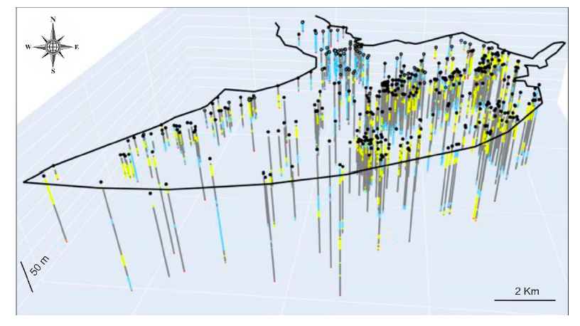
On the basis of the high density of boreholes and the subsequent geological knowledge gained during the last six decades, the Quaternary onshore Llobregat River Delta in northeastern Spain was selected to show the application. The public granulometry dataset produced by the Water Authority of Catalonia from 433 boreholes in this strategic coastal groundwater body was clustered into the clay–silt, coarse sand, and gravel classes. Three interactive 3D HTML models were created. The first shows the location of the boreholes granulometry. The second includes the main gravel and coarse sand sedimentary bodies (lithosomes) associated with the identified three stratigraphic intervals, called lower (>50 m b.s.l.) in the distal Llobregat Delta sector, middle (20–50 m b.s.l.) in the central Llobregat, and upper (<20mb.s.l.) spread over the entire Llobregat. The third deals with the basement (Pliocene and older rocks) top surface, which shows an overall steeped shape deepening toward the marine platform and local horsts, probably due to faulting. The modeled stratigraphic elements match well with the sedimentary structures reported in recent scientific publications.
This proves the good performance of this incipient Python application for visualizing the 3D stratigraphic architecture, which is a crucial stage for groundwater management and governance.
Sierra Espuña Malaguide an example of geological heritage
The Cenozoic Malaguide Basin from Sierra Espuña (Internal Betic Zone, S Spain) due to the quality of outcropping, areal representation, and continuity in the sedimentation can be considered a key-basin. In the last 30 years, a large number of studies with very different methodological approaches have been done in the area. Models indicate an evolution from passive margin to wedgetop basin from Late Cretaceous to Early Miocene. Sedimentation changes from limestone platforms with scarce terrigenous inputs, during the Paleocene to Early Oligocene, to the deep basin with huge supplies of turbidite sandstones and conglomerates during the Late Oligocene to Early Miocene. The area now appears structured as an antiformal stack with evidence of synsedimentary tectonics. The Cenozoic tectono-sedimentary basin evolution is related to three phases: (1) flexural tectonics during most of the Paleogene times to create the basin; (2) fault and fold compartmentation of the basin with the creation of structural highs and subsiding areas related to blind-fault-propagation folds, deforming the basin from south to north during Late Oligocene to Early Aquitanian times; (3) thin-skin thrusting tectonics when the basin began to be eroded during the Late Aquitanian-Burdigalian. In recent times some works on the geological heritage of the area have been performed trying to diffuse different geological aspects of the sector to the general public. A review of the studies performed and the revisiting of the area allow proposing different key-outcrops to follow the tectono-sedimentary evolution of the Cenozoic basin from this area. Eight sites of geological interest have been selected (Cretaceous-Cenozoic boundary, Paleocene Mula Fm, Lower Eocene Espuña- Valdelaparra Fms, Middle Eocene Malvariche-Cánovas Fms, Lowermost Oligocene As Fm, Upper Oligocene-Lower Aquitanian Bosque Fm, Upper Oligocene-Aquitanian Río Pliego Fm, Burdigalian El Niño Fm) and an evaluation has been performed to obtain four parameters: the scientific value, the educational and touristic potential, and the degradation risk. The firsts three parameters obtained values above 50 being considered of “high” or “very high” interest (“very high” in most of the cases). The last parameter shows always values below 50 indicating a “moderate” or “low” risk of degradation. The obtained values allow us considering the tectono-sedimentary evolution of this basin worthy of being proposed as a geological heritage.
Evolutionary geological models of the central-western peri-Mediterranean chains
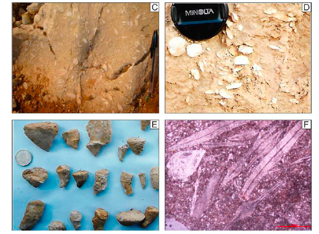
Two main groups of geological models presented over the last four decades on the paleogeographic, paleotectonic and geodynamic eo-Alpine and neo-Alpine evolution of the central-western Mediterranean area were compared. The comparison was carried out mainly considering the main stratigraphic, sedimentological, petrographic, structural and plate tectonic constraints. Moreover, recent geophysical interpretations and reconstructions were also considered with an aim of presenting all the different results. The models can roughly be grouped into two main classes. First family considers the presence of the Mesozoic Tethyan Ocean, where a single oceanic basin is located between Africa and Europe and from which both eo-Alpine and neo-Alpine chains were generated during the Cretaceous to Miocene time span. Conversely, the other class considers the occurrence of at least two Tethyan oceanic branches (or with thinned continental crust) since the Jurassic, separated by one or more microcontinents. The pros and cons of both classes of models are presented. Progressive innovations and improvements to the two groups of models were proposed over the years. However, because the modelsare based on different data sets resulting from basic geological studies or obtained by means of other approaches, they often do not integrate easily.This caused interpretative difficulties and terminological uncertainties for their comparison, and completely different models were considered equivalent and, sometimes, the same terminology was used indifferently to identify different geological subjects. The main differences between the examined models concern the kinematic reconstructions and by hence in the paleogeographic and paleotectonic interpretations. The discussion presented in this paper aims at contributing to clarify and update the state of knowledge on this controversial topic.
Oligo-Miocene evolution of the Paratethyan branches
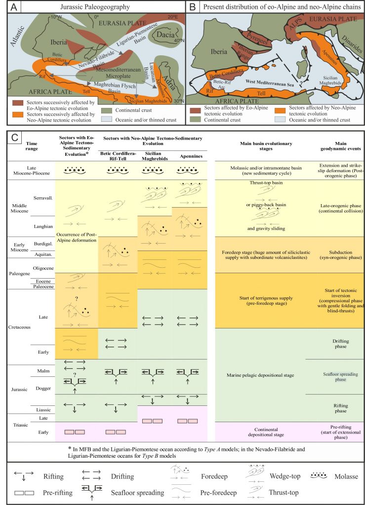
A comparison of the stratigraphic record between two different branches of the Tethys is attempted for the first time. This study concerns the main Oligocene-Miocene tectono-sedimentary events in the Cenozoic units of the Moldavidian Basin (Romanian Eastern Carpathians) and the Maghrebian Flysch Basin (Maghrebian Chain and its lateral extension in the Betic and Southern Apennine Chains). Both basins are characterized by three main general Oligo-Miocene successions (internal, mixed, and external) corresponding to three subdomains controlled by the geological evolution of opposite plate (or microplate) margins and affected by a similar tectonic evolution. The successions of the three subdomains of the two basins show very similar features regarding stratigraphic records (lithofacies and petrofacies associations, unconformities, marker-levels, age), and the space-time sediment supply diversification (i.e., immature and super-mature arenites coming from opposite margins). Furthermore, pre-, syn- and post-orogenic successions have been identified in the geological reconstructions of both basins. The tectonic control on depositional processes (i.e., a large amount of siliciclastic supply confined in restricted time ranges, widespread volcaniclastites linked to acid-intermediate penecontemporaneous volcanic activity), and the appearance of indicators of syn-sedimentary tectonic activity (turbidites, slumps, and olistostromes) result in correlable events related to deformation phases that in turn are indicative of a similar evolution. Also, the basinal evolutionary stages (i.e., beginning of terrigenous supply, thrust-top basin formation and gravitational sliding, molassic and/or intramontane sedimentary cycles), the timing of deformation phases (drifting, foredeep), and geotectonic events (from extension to compression and post-orogenic deformation) seem to be similar. All results are encompassed in an evolutionary geodynamic model considered in the context of the Africa-Europe convergence where intermediate microplates are involved. This complex framework implies a progressive reorientation of convergence direction of these microplates that occurs during similar geodynamic events leading to the closure of the western Tethys Ocean and its related late-Alpine branches. This comparative approach, if applied to similar evolutionary phases of other mountain chains, can be useful for different geological contexts of other orogenic belts, especially to check the major general geological constraints for their evolution.
Jimenez de Cisneros exhibition at Crevillent
In the Crevillent town takes place an exhibition on the geologist Daniel Jimenez de Cisneros celebrating the 100 years of the publication of the first geological study of the Crevillent Sierra.
The University of Alicante has been collaborating in the exhibit 15-years after the 2004-tribute-simposium to Don Daniel Jimenez de Cisneros. The link bellow show two videos made for the event.
Catoon trailer:
link to the facsimil-book published:
Tectonic breakup in the Eastern Betic zone
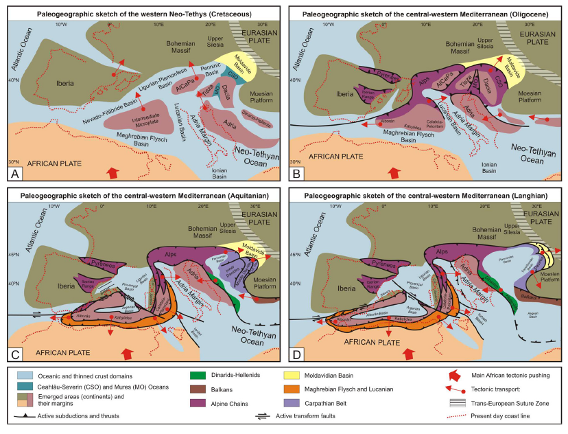
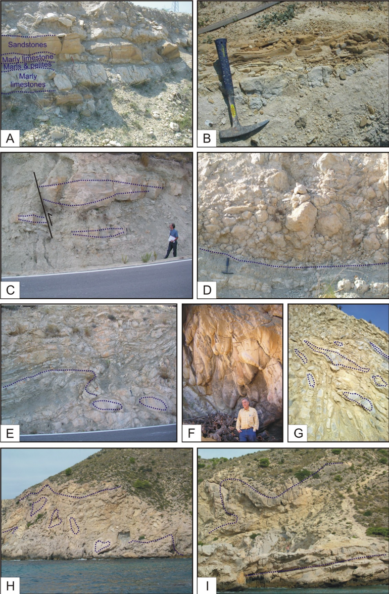
Six Paleogene-Aquitanian successions have been reconstructed in the Alicante area (eastern External Betic Zone). The lithofacies association evidences “catastrophic” syn-sedimentary tectonic processes consisting of slumps, mega-olisthostromes, “pillow-beds” and turbiditic deposits (Figure 1).
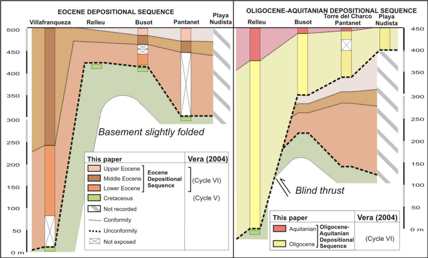
This kind of sedimentation is related to unconformity surfaces delimiting sequence and para-sequence cycles in the stratigraphic record (Figure 2).
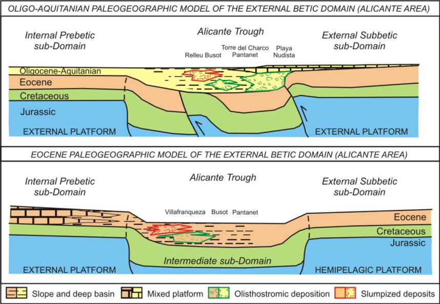
The data compiled have enabled the reconstruction of the Paleogene-Aquitanian paleogeographic and geodynamic evolution of this sector of the External Betics. During the Eocene the sedimentary basin is interpreted as a narrow trough affected by (growth) folding related to blind thrust faulting with a source area from the north-western margin, while the southeastern margin remained inactive. During the Oligocene-Aquitanian, the sourcing margin became the southeastern margin of the basin affected by a catastrophic tectonic (Figure 3).
The activity of the margins is identified from specific sediment sources area for the platform-slope-troughsystem and from tectofacies analysis. The southeastern South Iberian Margin is thought to be closer to the Internal Betic Zone, which was tectonically pushing towards the South Iberian Margin. This pushing could generate a lateral progressive elimination of subbetic paleogeographic domains in the eastern Betics (Figure 4).
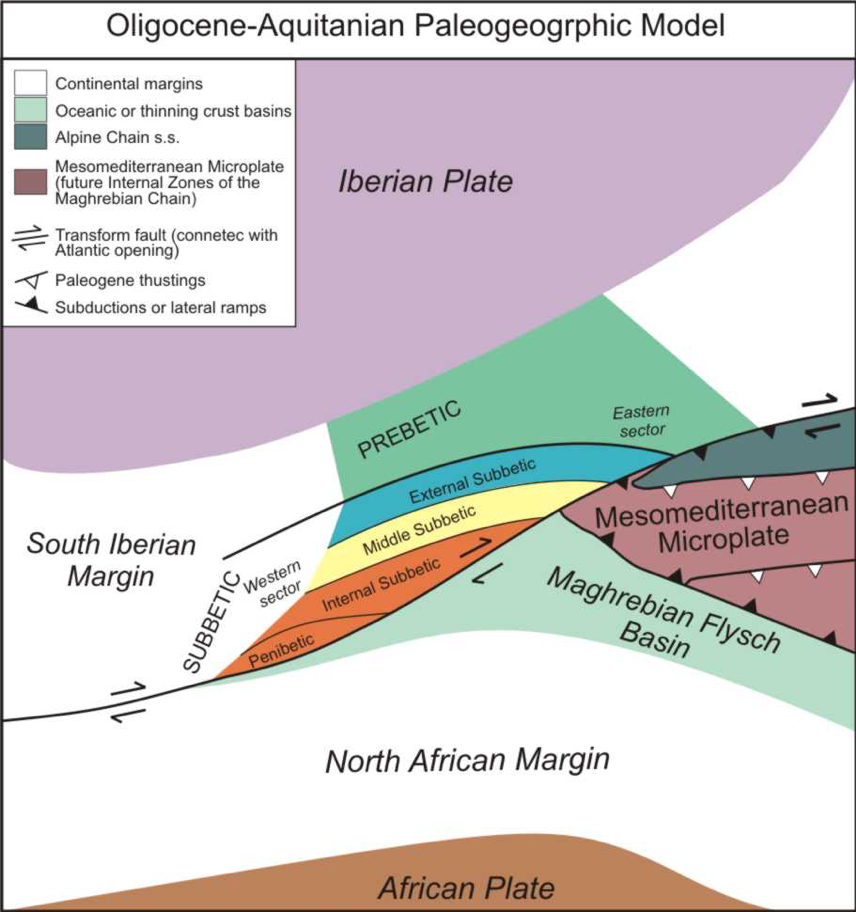
This geodynamic frame could explain the development of such “catastrophic” tectono-sedimentary processes during the Late Oligocene-Early Miocene.
Source areas in the Agost Basin (Betic Cordillera)
A new work to illustrate a changes in source areas related with pull-apart basin in the Betics. Here the link to the work in researchgate.
Sedimentary and mineralogical analyses were performed in the Neogene Agost Basin (External Domain, Betic Cordillera) to reconstruct relationships between tectonics and sedimentation, and source areas evolution over time.
Geological Setting
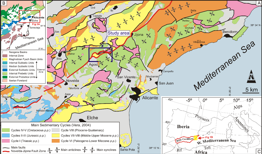
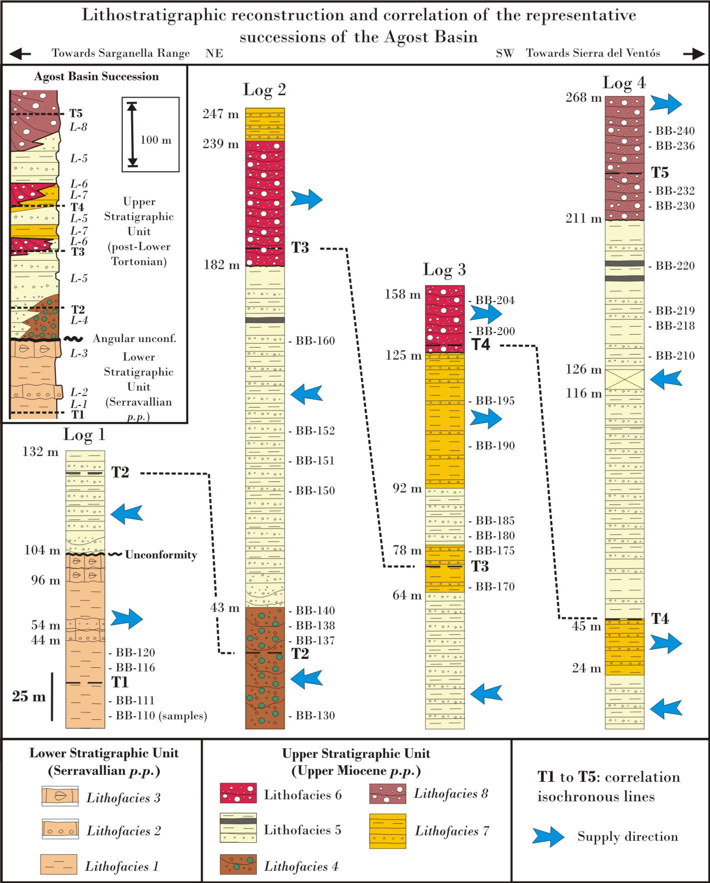
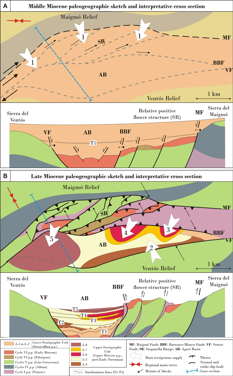
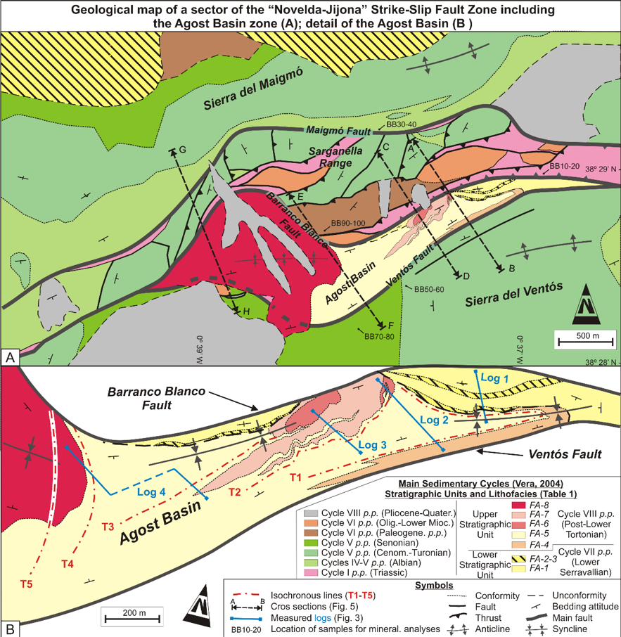
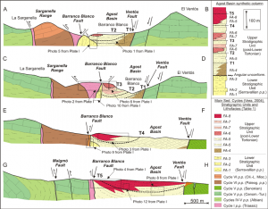
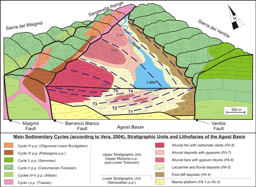
The sedimentary analysis allowed defining two sedimentary sequences: (1) Lower Stratigraphic Unit, Serravallian p.p. and (2) Upper Stratigraphic Unit, post Lower Tortonian (Upper Miocene p.p.)separated by an angular unconformity. They consist of marine (lithofacies L-1to L-3) and continental (lithofacies L-5to L-8) deposits respectively (Figure 2).
The analysis of mineralogical assemblages and some XRD parameters of the sedimentary sequences (Figure 3) and older formations (Figure 4) allowed recognizing a sedimentary evolution controlled by the activation of different source areas over time.
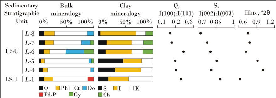

In particular, the Ill+Kln±Sme+Chl clay-mineral association characterizes the supply from Triassic formations; the Ill+Kln+Sme association from Albian formations; the Sme+Ill±Kln+(I-S) and Sme+Ill±Kln associations from Upper Cretaceous p.p.formations; and the Sme+Ill±Kln+(I-S) association from Paleogene formations, testifying a tectonic mobility of the basin margins differentiated over time (Figure 5).
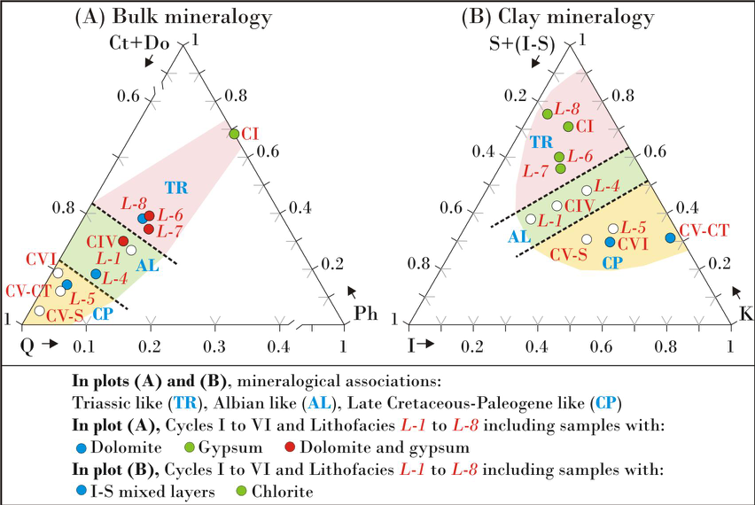
This reconstruction leads to propose detailed relationships between types of deposits and provenance and not a classic “unroofing”, as follows: (i) the lithofacies L-1 (lithofacies L-2 and L-3 were not analysed) is characterized by the Ill+Kln+Sme mineralogical association indicating an origin from the Albian formations; (ii) the lithofacies L-4 shows a mixture of Ill+Kln+Sme and Sme+Ill+Kln associations sourced from the Albian and Upper Cretaceous formations; (iii) the lithofacies L-5 is characterized by the Sme+Ill±Kln+(I-S) association indicating a provenance from the Upper Cretaceous and Paleogene formations; (iv) the lithofacies L-6 to L-8 are characterized by the Ill+Kln±Sme+Chl association indicating a supply mainly from Triassic deposits. The evolutionary sedimentary model reconstructed for the Agost Basin, which improves a previous contribution about the same area, has been correlated with those reported in other intramontane Neogene basins in the Betic-Rifian Arc studied with similar resolution, so obtaining useful information for regional reconstructions.
The Agost Basin (Betic Cordillera, Alicante province, Spain): a pull-apart basin involving salt tectonics
A new work to illustrate a strike-slip basin in the Betics. Here the link to the publisher.
The Agost Basin is characterized by a Miocene-Quaternary shallow marine and continental infilling controlled by the evolution of several curvilinear faults involving salt tectonics derived from Triassic rocks. From the Serravallian on, the area experienced a horizontal maximum compression with a rotation of the maximum stress axis from E-W to N-S.

Geological setting
The resulting deformation gave rise to a strike-slip fault whose evolution is characterized progressively by three stages (see Figure 4): (i) stepover/releasing bend with a dextral motion of blocks; (ii) very close to pure horizontal compression; and (iii) restraining bend with a sinistral movement of blocks.
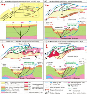
In particular, after an incipient fracturing stage, faults generated a pull-apart basin with terraced sidewall fault and graben subzones developed in the context of a dextral stepover during the lower part of late Miocene p.p. The occurrence of Triassic shales and evaporites played a fundamental role in the tectonic evolution of the study area. The salty material flowed along faults during this stage generating salt walls in root zones and salt push-up structures at the surface. During the purely compressive stage (middle part of late Miocene p.p.) the salt walls were squeezed to form extrusive mushroom-like structures. The large amount of clayish and salty material that surfaced was rapidly eroded and deposited into the basin, generating prograding fan clinoforms. The occurrence of shales and evaporites (both in the margins of the basin and in the proper infilling) favored folding of basin deposits, faulting, and the formation of rising blocks. Later, in the last stage (upper part of late Miocene p.p.), the area was affected by sinistralrestraining conditions and faults must have bent to their current shape. The progressive folding of the basin and deformation of margins changed the supply points and finally caused the end of deposition and the beginning of the current erosive systems. On the basis of the interdisciplinary results, the Agost Basin can be considered a key case of the interference between salt tectonics and the evolution of strike-slip fault zones. The reconstructed model has been compared with several scaled sandbox analogical models and with some natural pull-apart basins.
Research supported by: Research Project CGL2016-75679-P, Spanish Ministry of Education and Science; Research Groups and Projects of the Generalitat Valenciana, Alicante University (CTMA-IGA); Research Group RNM 146, Junta de Andalucía; Grants from University of Urbino “Carlo Bo”, responsible M. Tramontana.
Recent Comments