Home » basin analysis
Category Archives: basin analysis
Cenozoic tectono-sedimentary evolution of the onshore-offshore Tunisian Tell: Implications for oil-gas research
A review of the paleogeographic and tectonic reconstruction of the onshore and offshore Tunisian margin during the Cenozoic is discussed. Five unconformities (A to E) and associated stratigraphic gaps of various vertical extents allow subdivision of the stratigraphic record into depositional units in the following time intervals: (i) Paleocene-Oligocene, (ii) Oligocene-early Aquitanian, (iii) early Aquitanian-Burdigalian, (iv) late Burdigalian-Langhian and (v) Langhian-late Miocene. These intervals can in turn be grouped into four main sedimentary cycles (SC1–SC4) dated to the (1) Paleocene-Oligocene, (2) Oligocene–Burdigalian, (3) Burdigalian-Langhian and (4) Langhian-late Miocene. The oldest depositional unit reflects Eo-Alpine tectonics in the Maghrebian Flysch Basin (MFB); the others are related to the Neo-Alpine syn- and late orogenic tectonic deformation affecting the MFB. The uppermost unit represents post-orogenic deposition. Early Miocene synsedimentary tectonism led to (1) deposition of thick successions owing to a large sediment supply and (2) the occurrence of various tectofacies (unconformities, slumps, mega-turbidites, olistostromes, growth folds, chaotic intervals and heterogenous lithofacies), that all, together with the occurrence of lateral change of facies, clearly indicate non-cyclical sedimentation. During the middle Miocene the Tunisian Tell underwent polyphase thrust tectonism, followed by late Miocene strike-slip deformation with contemporaneous rejuvenation of halokinetics and magmatism (the La Galite Archipelago) that may be traced as far as the Algerian Tell. The margin experienced deep-seated compressional tectonism during the Paleogene, a foreland basin during the early Miocene, and nappe stacking during the middle Miocene, with the occurrence of wedge-top sub-basins. The evolution of the region makes the existence of petroleum resources within either the thrust belt, the foredeep and/or the foreland systems plausible. Oil and/or gas may have been trapped in either i) deep buried allochthonous thrust wedges that are located below the Numidian Nappes, and/or in ii) the imbricate Medjerda Valley domain of the Tell foredeep. The offshore area between northern Tunisia and the La Galite Archipelago may also hold potential for large oil/gas fields, as has been confirmed by exploration of the same overthrust belt in other areas such as in Sicily and the Southern Apennines.
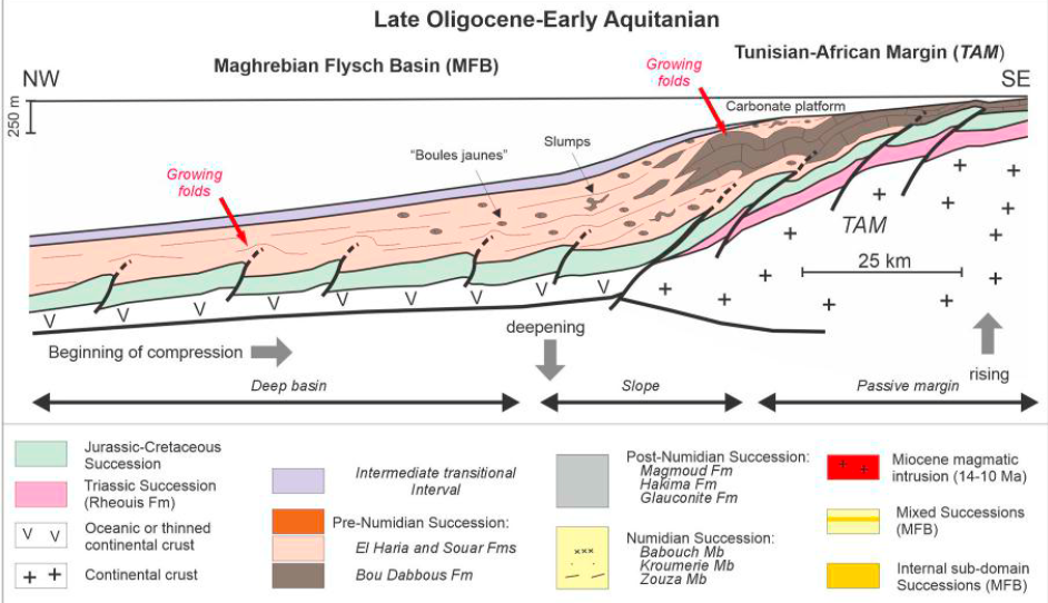
Hypothetical Tunisian margin offshore (revised after Belayouni et al., 2013).
Cite as: Belayouni, H., Guerrera, F., Martín-Martín, M., Tramontana, M., Bullejos, M. (2023). Cenozoic tectono-sedimentary evolution of the onshore-offshore Tunisian Tell: Implications for oil-gas research. Marine and Petroleum Geology 156 (2023) 106426
A Python Application for Visualizing an Imbricate Thrust System: Palomeque Duplex (SE, Spain)
This paper introduces a Python application for visualizing an imbricate thrust system. The application uses the traditional geologic information to create an HTML geological map with real topography and a set of geological cross-sections with the essential structural and stratigraphic elements. On the basis of the high geological knowledge gained during the last three decades, the Palomeque sheets affecting the Cenozoic Malaguide succession in the Internal Betic Zone (SE Spain) were selected to show the application. In this area, a Malaguide Cretaceous to Lower Miocene succession is deformed as an imbricate thrust system, with two thrusts forming a duplex, affected later by a set of faults with a main strike-slip kinematic. The modeled elements match well with the design of the stratigraphic intervals and the structures reported in recent scientific publications. This proves the good performance of this Python application for visualizing the structural and stratigraphic architecture. This kind of application could be a crucial stage for future groundwater, mining, and civil engineering management.
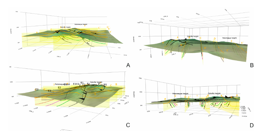
Cite as: Bullejos, M., Martín-Martín, M., 2023. A Python Application for Visualizing an Imbricate Thrust System: Palomeque Duplex (SE, Spain). Geosciences. https://doi.org/10.3390/geosciences13070207
Supplementary Materials: The following supporting information can be downloaded at: https://www. mdpi.com/article/10.3390/geosciences13070207/s1: interactive 3D geological map: 3D_Palomeque_map_sections.html; interactive 3D geological sections: 3D_Palomeque_map_sections.html. Python codes and the detailed instructions to download and run the codes can be found in a GitHub repository at: https://github.com/bullejos/visualizing-an-imbricate-thrust-system.
Field work in the Eocene Prebetic II
The rain in Spain…
Well the second field work campaign in the Eocene Prebetic was conditional by the bad weather, rain, wind, snow and cold.
The picture shows the members of the team imply in this field try to the Eocene rocks within the provinces of Alicante and Murcia.
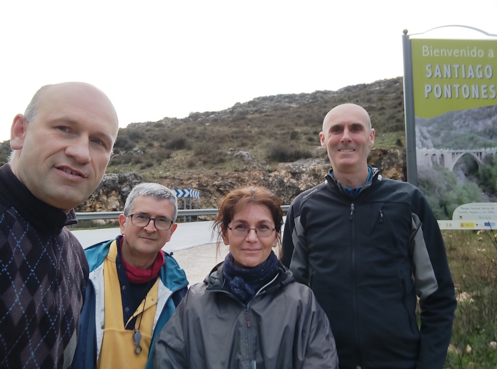
This is the second field season of the project of the Spanish research agency (Agencia Estatal de Investigación) of the Spanish Science and innovation minister (Ministerio de Ciencia e Innovación) entitle as “EVOLUCION TECTONO-DEPOSICIONAL DE CUENCAS SEDIMENTARIAS CENOZOICAS: CARACTERIZACION 2D-3D Y MEJORA DE PATRONES ESTANDAR” (PID2020-114381GB-I00). See previous post.
Field work in the Eocene Prebetic
The good weather in Alicante during the winter season has permitted to do the first field season of our project of the Spanish research agency (Agencia Estatal de Investigación) of the Spanish Science and innovation minister (Ministerio de Ciencia e Innovación) entitle as “EVOLUCION TECTONO-DEPOSICIONAL DE CUENCAS SEDIMENTARIAS CENOZOICAS: CARACTERIZACION 2D-3D Y MEJORA DE PATRONES ESTANDAR” (PID2020-114381GB-I00). See previous post.
The picture shows the members of the team imply in this field try to the Eocene rocks within the provinces of Alicante and Murcia.
Crina Miclaus (Alexandru Ioan Cuza University)
Josep Tosquella (Huelva University)
Manuel Martin-Martin (Alicante University)
Jose Enrique Tent-Manclus (Alicante University)

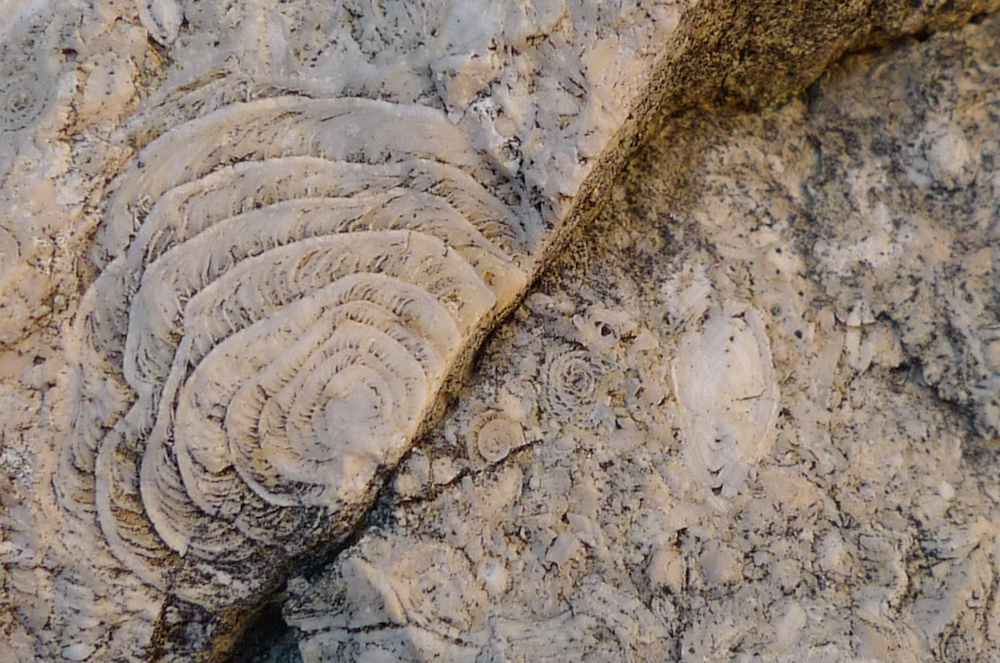
Next picture shows a nummulite-rich limestone in a quarry near Onil, one of the visited sections in our field work.
New project to study sedimentary basins.
The Spanish research agency (Agencia Estatal de Investigación) of the Spanish Science and innovation minister (Ministerio de Ciencia e Innovación) has conceded a new project to study the Cenozoic sedimentary basins entitle as “EVOLUCION TECTONO-DEPOSICIONAL DE CUENCAS SEDIMENTARIAS CENOZOICAS: CARACTERIZACION 2D-3D Y MEJORA DE PATRONES ESTANDAR” (PID2020-114381GB-I00).
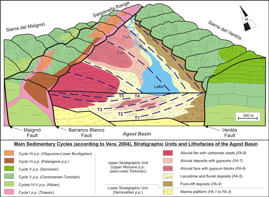
This research project will develop techniques for the analysis of various types of Cenozoic sedimentary basins in a general compressive or convergent framework (associated with strike-slip faults, transported -piggy-back or wedge-top-, and complex foreland systems). The stratigraphic architecture, biostratigraphic control of the different sedimentary bodies, stratigraphic discontinuities will be studied, as well as sediments sources (both terrigeneous and biogenic) through mineralogical, petrographic and geochemical studies.
TEAM
Principal investigator: Manuel Martín-Martín (Alicante University)
Jesús M. Soria (Alicante University)
Manuel Bullejos Lorenzo (Granada University)
Antonio Sánchez Navas (Granada University)
Agustín Martín-Algarra (Granada University)
José Enrique Tent-Manclús (Alicante University)
Josep Tosquella (Huelva University)
Carlos Ureña Almagro (Granada University)
Fernando Pérez-Valera (Alicante University)
Francisco Javier Alcalá-García (Instituto Geológico y Minero de España, IGME)
Estelle Mortimer (University of Leeds)
Douglas Patton (University of Leeds)
Francesco Perri (Calabria University)
Salvatore Critelli (Calabria University)
Crina Miclaus (Alexandru Ioan Cuza University)
Francisco Serrano (Malaga University)
Compactation in sedimentary basins
Subsidence analysis is an important technique in the study of sedimentary basins but the effects of compaction must be “backstripped”. The compaction of sediments is also of importance for petroleum and water reservoir research with very important economic derivations. Most methods for calculating compaction are based on empirically derived porosity-depth relationships from a variety of known sediment types. The challenge of this paper is to apply alternative methods for calculating compaction in sedimentary basins based on: physical calculation with elastic by Steinbrenner, oedometric and change of the specific weight of the sediment methods; and use of Loadcap software.
The Triassic to Lower Miocene 3025m thick succession of Sierra Espuña (SE Spain) is used as case study for the calculations. In this succession former mineralogical studies and apatite fission-track suggested an original thickness between 4 and 6km. The validity of each one of the proposed methods is discussed, as well as, compared for the whole succession compaction but also separately for hard vs soft sediments and for thick vs thin beds.
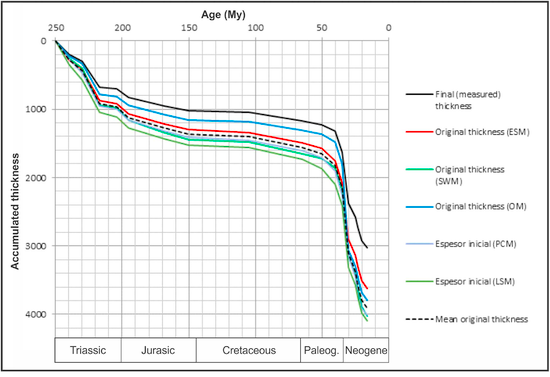
The compaction values obtained with the alternative methods are similar to those resulting with the lower-limit curves of the porosity-depth change method. The new methods have provided values slightly higher than 4km for the whole original thickness using the geotechnical software and the change of the sediments specific weigh methods; meanwhile values below 4km for other methods. So, in our opinion, the geotechnical software and the change of the specific weight of the sediment methods are compatible with mineralogical constraints and also, the input data are usually better known and easier to determinate. Otherwise, the elastic method seems only accurate for soft sediments; meanwhile the oedometric method is highly influenced by the thickness of the considered beds.
Recent Comments