Three of the top cited paper, the first one, Criniti et al. (2023), the fourth one, Martín-Martín et al. (2023a), and the seventh, Martín-Martin et al., (2023b), have been written by our group, and have been referred in this blog.
Three of the top cited paper, the first one, Criniti et al. (2023), the fourth one, Martín-Martín et al. (2023a), and the seventh, Martín-Martin et al., (2023b), have been written by our group, and have been referred in this blog.
According to classical literature, two Paleogene platforms developed along the northern and southern margins of the Neo-Tethys Ocean. Similar platforms have been recognized on the southern margin of a “lost domain” consisting of an independent microplate known as the “Mesomediterranean Microplate” (MM) in the westernmost Neo-Tethys Ocean. This microplate underwent tectonic dismantling and drifting during the opening of the western Mediterranean. The individualized blocks collided with the European and African palaeomargins during the Miocene, forming the Neo-Alpine chains of the western Mediterranean. The regional reconstruction and lateral correlation of Paleogene deposits have provided valuable insights into the paleogeographic and geodynamic evolution of this lost domain. The most representative Paleogene successions lie unconformably over the Palaeozoic basement and Mesozoic sedimentary cover. The sedimentary evolution, source areas, peleoclimate and palaeoenvironments recognized along the Betic and Maghrebian (Rif, Tell, Calabria-Peloritani Arc) chains have also been compared. Reconstructions of the MM using GPlates software have placed the original position of these platforms approximately at 30◦ N, and between 5◦W and 10◦E. Along the southern border of this microplate, a northward transition towards continental areas and a southward transition into deeper marine domains were identified. Additionally, distinctions were made between areas with complete Paleogene successions and those with condensed successions, as well as between carbonate-dominated and siliciclastic-dominated platforms.
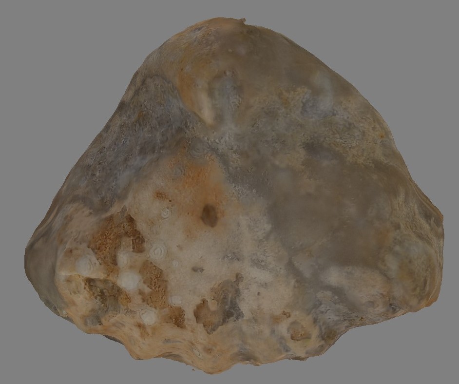
Early Jurassic multicostate Terebratulida are substantiated in the Subbetic Domain and reported in the Iberian Range for the first time. Records of this clade are revised in the peri-Iberian platforms (Subbetic, Iberian Range, Gibraltar, North and NE Spain, Lusitanian basin) in order to evaluate their global pattern distribution across the Tethys Ocean. After a new tectonosedimentary analysis, marine swells are proposed as depositional scenarios for the assemblages containing Hesperithyris aff. sinuosa in the southernmost Subbetic paleomargin, sheding light to the intrincate paleogeography of this part from the Betic Range. In the Iberian Range, the same species and Merophricus ? fimbrioides occurred in extensive flooding intervals arriving from the deepest marine populations. As results of taxonomic and paleobiogeographical analyses, two morphotypes, Merophricus – and Hesperithyris -type, are discriminated forming part of the westernmost Tethys migration route. It can be ascertained that their E-W Tethyan spreading was fulfilled for the Merophricus -type from the intra-Mediterranean basins to the westernmost arc of the Tethys Ocean, via the Betic–Gibraltar seaway, reaching the proto-Atlantic northwards (Lusitanian basin) and possibly the northern margin of the Iberian Massif and Western France. In contrast, Hesperithyris aff. sinuosa from the Iberian and Betic ranges correspond to the intra- and peri-Mediterranean Hesperithyris– type, with a different dispersal pattern. The only Lower Jurassic Hesperithyrys -type multicostate terebratulides reported in the boundaries of the NW-Boreal bioprovince derive from the Northeastern Iberian paleomargins, probably due to sporadic incursion events at transgressive episodes. The row of Subbetic epioceanic seamount stepping stones helped the Merophricus -type migration in the E-W Mediterranean route and their pivotal position facilitated the dispersal of both morphotypes via the epicontinental Iberian seaway. In the Subbetic, the Hesperithyris bearing assemblages are recorded in the Pliensbachian Lavinianum Zone (Portisi and Cornacaldense subzones) equivalent to the basal part of the Margaritatus Zone (Stokesi Subzone) from the Iberian Range where the same species is now recorded, thus correlating the Southern epioceanic paleomargins with the Eastern epicontinental platforms. The origin and dispersal of the Merophricus -type around the Si–Pl boundary concurred with the Western Tethys early pre-rifting stage, and the pre-Domerian drowning of Tethyan platforms is synchronically consistent with the origin and spreading of the Hesperithyris -type.
The Africa call…
Well the third field work campaign the project. This time in the Middle Atlas of Morocco. The objetive was to find Nummulites as the ones in the Betic or in the Rif.
The picture shows the members of the team. Picture taken by Soufian Maaté.
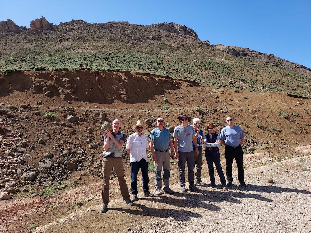
Quaternary basalts near Bekrit (Middle Atlas). From left to right: Manuel Martín-Martín, Ali Maaté, Pedro Robles, José Enrique Tent-Manclús, Manuel Bullejos, Crina Miclăuș, and Santiago Moliner
Manuel Bullejos Lorenzo (Granada University)
Rachid Hlila (Abdelmalek Essaádi University)
Ali Maaté (Abdelmalek Essaádi University)
Manuel Martín-Martín (Alicante University)
Soufian Maaté (Moulay Ismail Errachidia University)
Crina Miclăuș (Alexandru Ioan Cuza University)
José Enrique Tent-Manclús (Alicante University)
And the collaborators:
Pedro Robles (Alicante University)
Santiago Moliner (Alicante University).
After a week (from April 23rd until April 30 2023). Many rock samples were taken and we did not find them but our hope is to look carefully the thin sections for tiny Nummulites.
This is the third major field trip of the project of the Spanish research agency (Agencia Estatal de Investigación) of the Spanish Science and innovation minister (Ministerio de Ciencia e Innovación) entitle as “EVOLUCION TECTONO-DEPOSICIONAL DE CUENCAS SEDIMENTARIAS CENOZOICAS: CARACTERIZACION 2D-3D Y MEJORA DE PATRONES ESTANDAR” (PID2020-114381GB-I00). See previous post.
A broad region of Mesozoic to Cenozoic tectonism along the western and central Circum- Mediterranean (CM) margins, from southern Spain (Betic Cordillera) to the northern Morocco (Rif) and Italy (Apennines), includes huge volumes of sedimentary record since the Late Paleozoic. These sediments are contemporaneous and related with the fragmentation of the Pangean supercontinent due to the rifting and progressive closure, as well as the following birth of the CM orogeny. The composition and stratigraphic relations of clastics in diverse sedimentary basins of the CM region reflect a complete record of provenance relations related to the progressive destruction of the Neotethyan Ocean and plate convergence between the two major plates of Europe and Africa, and Iberia, Adria and Mesomediterranean microplates located between them. The changing nature of clastic wedges reflects the provenance relations from different source rocks involving obduction of the oceanic lithosphere, the uplifted Alpine-Mediterranean Chains, and the accreted previously deformed Mesomediterranean Microplate (AlKaPeCa), as well local neovolcanic sources, within the spatial and temporal evolving geo-puzzle terranes of the CM orogeny. The provenance evolution of sediment provides insights into how plate convergence and continental collision direct the sediment dispersal pathway in Cenozoic basins due to closure of eastern and southern Alpine-Tethyan remnant ocean basins and to the dual dispersal pathways from the previously born Alps and the nascent AlKaPeCa at the expenses of the previously deformed Mesomediterranean terranes. The source-to-sink relations testify episodic deformation events, diachronous Tethyan basin development, differentiate sediment provenance from exhumed and uplifted Alpine and CM orogens, and palaeogeographic rearrangement of crustal blocks along the nascent Mediterranean region.
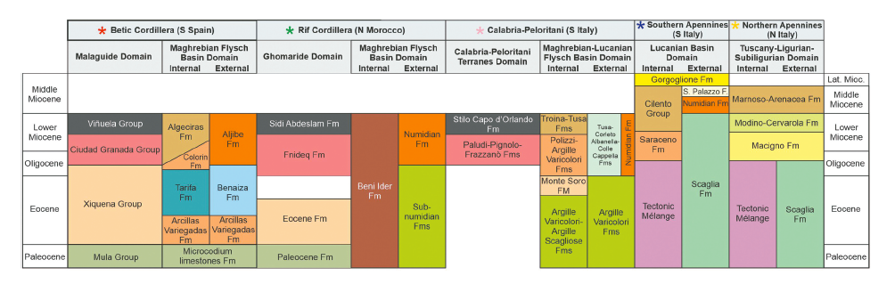
Correlation of composite stratigraphic chart within the circum-Mediterranean orogeny. Stars are the key stratigraphic sections of this work. Adapted from Critelli and Martín-Martín (2022).
cite as: Critelli, S.; Martín-Martín, M. 2023. History of Western Tethys Ocean and the Birth of the Circum-Mediterranean Orogeny as Reflected by Source-to-Sink Relations. Int. Geol. Rev. 1–11, doi:10.1080/00206814.2023.2280787.
This paper introduces a Python application for visualizing an imbricate thrust system. The application uses the traditional geologic information to create an HTML geological map with real topography and a set of geological cross-sections with the essential structural and stratigraphic elements. On the basis of the high geological knowledge gained during the last three decades, the Palomeque sheets affecting the Cenozoic Malaguide succession in the Internal Betic Zone (SE Spain) were selected to show the application. In this area, a Malaguide Cretaceous to Lower Miocene succession is deformed as an imbricate thrust system, with two thrusts forming a duplex, affected later by a set of faults with a main strike-slip kinematic. The modeled elements match well with the design of the stratigraphic intervals and the structures reported in recent scientific publications. This proves the good performance of this Python application for visualizing the structural and stratigraphic architecture. This kind of application could be a crucial stage for future groundwater, mining, and civil engineering management.
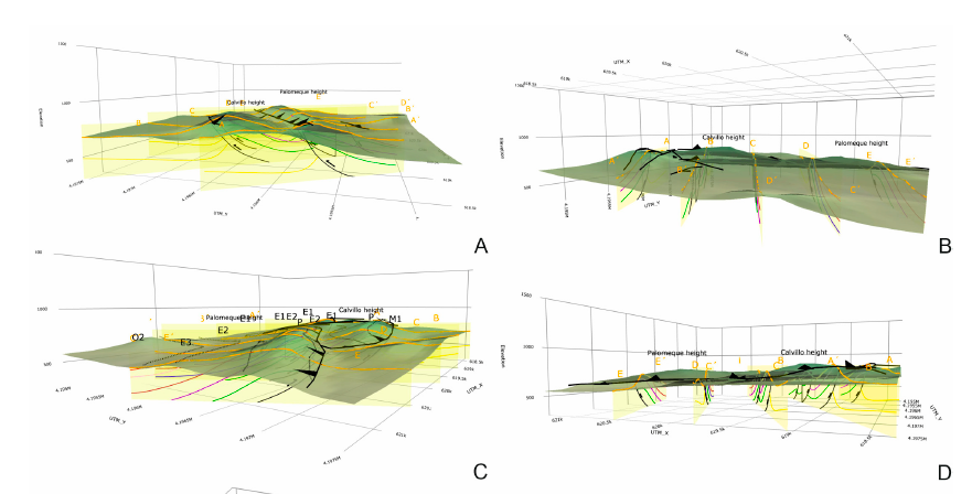
Screenshots with views of the interactive geological map with real topography and geological cross-sections performed by Python, provided in Supplementary Material. (A) lateral view from the W; (B) lateral view from the S; (C) lateral view from the NE; (D) lateral view from the N.
Cite as: Bullejos, M., Martín-Martín, M., 2023. A Python Application for Visualizing an Imbricate Thrust System: Palomeque Duplex (SE, Spain). Geosciences. https://doi.org/10.3390/geosciences13070207
Supplementary Materials: The following supporting information can be downloaded at: https://www. mdpi.com/article/10.3390/geosciences13070207/s1: interactive 3D geological map: 3D_Palomeque_map_sections.html; interactive 3D geological sections: 3D_Palomeque_map_sections.html. Python codes and the detailed instructions to download and run the codes can be found in a GitHub repository at: https://github.com/bullejos/visualizing-an-imbricate-thrust-system.
A synthesis of Cenozoic detrital suites from the Internal Betic-Rif Cordilleras is discussed in relations with major paleotectonic phases during growth of orogenic belts. The discussion has been focused on the Malaguide and Ghomaride complexes that have a Cenozoic sedimentary detritic cover. The heterogeneous petrographic composition of coarse detrital rocks, and the mineralogy and geochemistry of mudrocks indicate a multiple source area consisting in metamorphic, and recycled siliciclastic and carbonate source rocks, with a minor supply of mafic rocks during the early Miocene. The siliciclastic coarse detrital suites plot mainly in a wide area at the Qm-Lt side in a Qm-F-Lt diagram reflecting their transition between a craton, quartzose recycled, quartzose transitional orogenic, and finally lithic transitional orogenic provenance type. The Paleocene-Eocene successions seem to be affected by higher weathering effects than the Oligo-Miocene ones. Significant recycling and reworking processes should take place during the Paleocene-Eocene and the Oligo-Miocene before the final deposition. The source areas were characterized by non-steady-state weathering conditions reflecting a progressive cooling contemporaneous to the typical evolution of source areas where active tectonism allows erosion within weathering profiles developed on source rocks. A sharp increase of siliciclastic content together with the changes in sorting-recycling-weathering suggests abrupt changes in the source area starting from Oligocene. This fact allows subdividing the succession into the lower (Paleocene-Eocene) and the upper (Oligocene-Early Miocene) cycles. Lower cycle was contemporaneous to the Eo-Alpine tectonic phase, which was reflected in the Malaguide and Ghomaride domains by basement folding and deep tectonics with fault-propagation folds, accomplished by minor rising or reliefs and deepening of subsidence areas. Contrarily, the upper cycle took place during the Neo-Alpine phase, when in the Malaguide and Ghomaride domains, thrustings should become superficial contemporaneous to subduction and stacking of tectonic units.
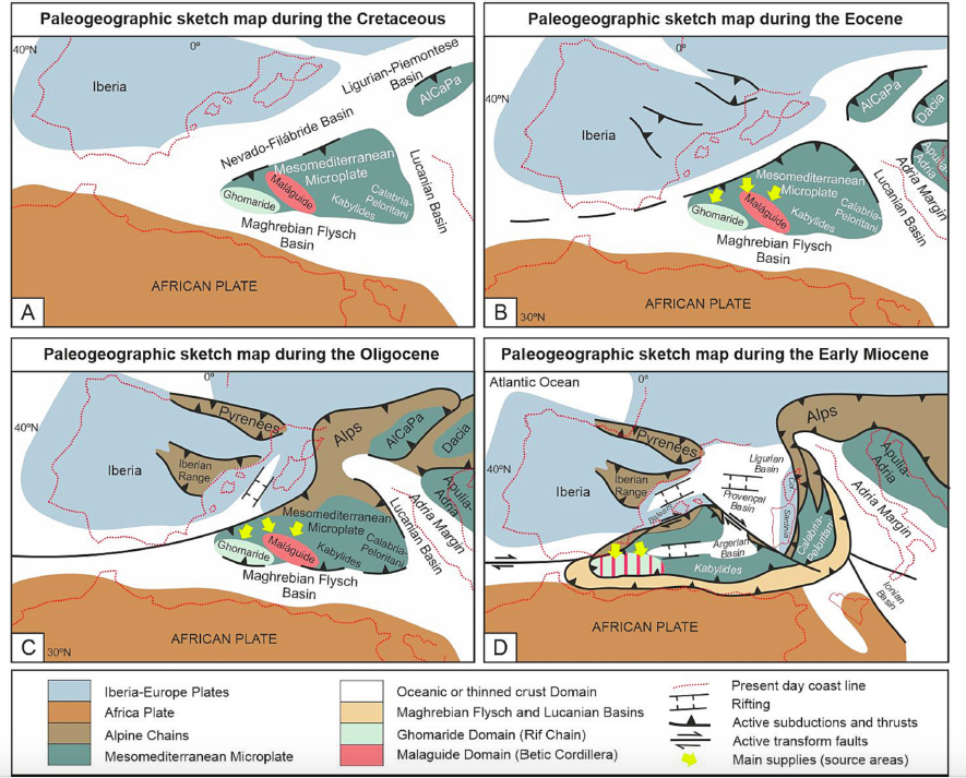
Paleogeographic and paleotectonic evolutionary models for the Central-Western Mediterranean area during the Cretaceous to Early Miocene with location of the Malaguide and Ghomaride Domains, as well as, main supplies and source areas. A) Cretaceous times sketch map (70 Ma); B) Eocene times sketch map (35 Ma); C) Oligocene times sketch map (25 Ma); D) Burdigalian times sketch map (20 Ma).
This led to a strong increasing of rising areas reflected in the sedimentation by the occurrence of coarse terrigenous deposits in wedge-top basins. The early Miocene also shows the influence of volcanism in the Mediterranean region, and/or the erosion of magmatic-metamorphic rocks derived from deep tectonic levels affected in the Eo-Alpine phase or belonging to the Hercynian bedrock. This evolution fits well with recent paleogeographic-geodynamic models for the western-central Mediterranean.
Cite as: Martín-Martín, M., Perri, F., Critelli, S., 2023. Cenozoic detrital suites from the Internal Betic-Rif Cordilleras (S Spain and N Morocco): implications for paleogeography and paleotectonics. Earth-Science Rev. 243, 104498. https://doi.org/10.1016/j.earscirev.2023.104498
The Eocene platform deposits in the Moroccan Ghomarides have been studied. These marine carbonate platforms were located in the westernmost Tethys approximately 30°N and 0°–10°W during the Cuisian to Bartonian. The study includes observations from fossiliferous assemblages (such as larger benthic foraminifera and colonial corals), their palaeoenvironment aswell as rock texture and fabric. Eight microfacieswere identified that represent different ramp environments in a ‘distally-steepened carbonate ramp’ type of platform. The studied deposits are organised into a transgressive succession composed of three sedimentary cycles: lower Cuisian, middle Cuisian and middle Lutetian to Bartonian. In the lower cycle, photic inner to mid ramp environments in mesotrophic conditions were prevalent. In the second cycle, photic inner ramp (sea-grass) to mid ramp environments inmesotrophic to oligotrophic conditions were observed. The upper cycle, which is more extensive and variable, represents mesophotic mid ramp to aphotic slope environments and changes gradually from oligotrophic to eutrophic conditions. During the Eocene, larger benthic foraminifera were dominant overtaking the zooxanthellate corals in the Tethys regions. Nevertheless, our study and the performed comparison with other Tethyan sectors have revealed that in some areas both coexisted in similar proportions. In some western Tethys regions close to the Atlantic Ocean, coinciding with areas influenced by upwelling currents, larger benthic foraminifera and coral build-ups were replaced by oyster reefs. The Ghomaride Domain represents an intermediate case between fossil assemblages of the northern Tethyan margin and eastern sector of the southern margin of the Tethys, with a dominance of larger benthic foraminifera but with a certain presence of corals as well. A good correlation exists between Eocene warm intervals and carbonate platform deposits in these domains. Contrarily, during cooling ones shallowing and gaps in the sedimentation are registered.
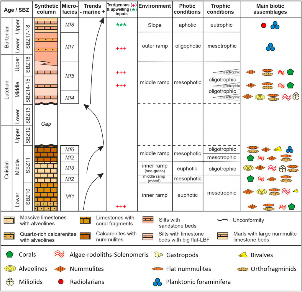
A synthetic column of the Eocene Ghomaride succession, highlighting the correlation with transgressive–regressive depositional trends, terrigenous-nutrient inputs, sedimentary environments, photic and trophic conditions and main biotic assemblages.
Two anomalies have been detected in the Ghomaride Domain during Ypresian and Bartonian times indicating particular climatic conditions or local tectonic interferences.
Cite as: Martín-Martín, M., Tosquella, J., Guerrera, F., Maaté, A., Hlila, R., Maaté, S., Tramontana, M., Le Breton, E., 2023. The Eocene carbonate platforms of the Ghomaride Domain (Internal Rif Zone, N Morocco): a segment of the westernmost Tethys. Sediment. Geol. 452, 106423. https://doi.org/10.1016/j.sedgeo.2023.106423
The Paleogene evolution of the NW margin of the African Plate (Western External Rif Zone) was studied by means of multidisciplinary analyses of twenty-one stratigraphic logs, including tectofacies recognition, petro-mineralogical results, and thicknesses analysis. Four stratigraphic intervals were recognized separated by three unconformities coarsely aligned with the Cretaceous–Paleogene, Eocene–Oligocene and Oligocene–Miocene boundaries, respectively. Tectofacies appear from the late Ypresian being more frequents from the Oligocene as the tectonic activity increases. The petrology of detrital suites indicates recycled orogen-derived sediments, with quartz supplied from metamorphic rocks of the Atlas orogen and/or the African craton. On the basis of Mesozoic claymineral assemblages reported in the literature, the clay mineralogy of mudstones suggests upper Jurassic to upper Cretaceous terrains from the Internal Intrarif as the main source area of the Paleocene–Eocene successions, with sediment provenance reversion during the Oligocene and additional contribution of Paleocene to lower Eocene suites. The different displacement capability of the identified aluminic-magnesic claymineralogy enabled to deduce the relative proximity of the source area. These findings point out a complex sedimentary evolution characterized by a mixture of different lithotypes dating back to upper Jurassic. X-ray parameters helped to identify evidences of synsedimentary tectonics overprinting the inheritedmineralogy during some periods with weak burial diagenesis at most.
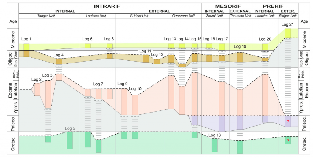
Paleogene stratigraphic framework of the western External Rif Zone, showing stratigraphic units, unconformities, and depositional vs. erosional gaps.
During the Paleogene a foreland basin is formed mainly in theMesorif and Prerif sub-domains. This foredeep was represented by two ‘sub-geosynclines’ separated by a relative bulge located in the External Mesorif. The Internal Intrarif could represent the relative orogenic front, advancing on the External Intrarif. The Eocene forebulge was located in the Ridges Domain, while the Gharb Basin was the backbulge of the system. During the Oligocene the depocentral area migrated southward and a homogeneization of thicknesses took also place in the whole margin. In this new configuration, the foredeep would be located in the External Mesorif (previously a relative bulge) while the Ridges Domain and the Gharb Basin continued to act as the system forebulge and backbulge, respectively. A comparison with the Paleogene evolution of other western Tethys external margins (Betic Chain, Tunisian Tell, Sicilian Maghrebids, and Apennines) has revealed more similarities than differences. The effects of the Eo-Alpine tectonics are recognized everywhere even if they decrease both from N to S, and from W to E in the different considered margins. The evolution of the compared margins shows a common pre-foredeed (Paleocene-Eocene) and beginning of foredeep (Oligocene) stages in the foreland basins.
Cite as: Martín-Martín, M., Guerrera F., Cañaveras, J. C., Alcalá F. J., Serrano, F., Maaté, A., Hlila, R., Maaté, S., Tramontana, M., Sánchez-Navas, A., and Le Breton, E. (2023). Paleogene evolution of the External Rif Zone (Morocco) and comparison with other western Tethyan margins. Sedimentary Geology, 448, 106367. doi: 10.1016/j.sedgeo.2023.106367
The widely debated late Oligocene-middle Miocene Numidian Fm (NF) consists of supermature quartzose sediments deposited in the Maghrebian Flysch Basin (MFB) outcropping from the Betic Cordillera to the Southern Apennine passing by the Maghrebian Chain. The NF is commonly composed of three lithostratigraphic members and is characterized by two vertical successions (Type A and Type B) corresponding to different sedimentation areas in the MFB. It is noteworthy the occurrence of widespread lateral successions of the NF (Types C, D and E) indicating in some cases an interference of the Numidian sedimentation with other different depositional systems and supplies. The Type C ‘Mixed Successions’, deposited in depocentre areas, are composed of supermature Numidian supply interfingering with immature siliciclastic materials, coming from the internal portion of the MFB. The Type D consists of supermature Numidian materials supplied from the Africa Margin (external sub-domains) deposited in sub-basins on the Africa-Adria margins, outside the typical Numidian depositional area. The Type E, which stratigraphically overlies both the South Iberian Margin (SIM) and the Mesomediterranean Microplate (MM), represents the migration of the Numidian depositional system to reach the opposite margins of the MFB. The occurrence at a regional scale of all the above-mentioned lateral successions reveals a great evolutionary complexity resulting also from further constraints, which must be considered for palaeogeographic and palaeotectonic reconstructions. Another important point deals with the diachronism of the top of the NF, observed eastward from the Betic-Rifian Arc and the Algerian-Tunisian Tell (Burdigalian p.p.) to Sicily (Langhian p.p.) and up to the Southern Apennine (at least Langhian/Serravallian boundary) which can be related with eastwards delay in the MFB closure.
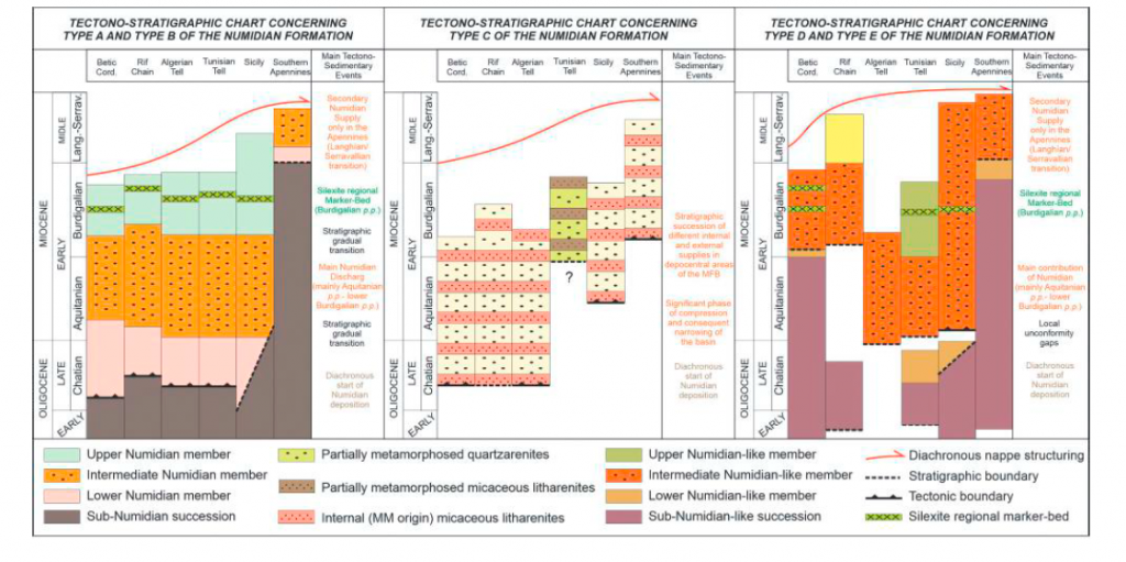
Tectono-stratigraphic charts concerning the Type A to Type E of the Numidian Formation depicting the lateral and vertical variability of the lithofacies, significant stratigraphic markers, surfaces and gaps of the stratigraphic record. The tectonic propagation along the chain is also represented.
The palaeogeographic reconstruction of the Numidian depositional area presented in this paper,which is also included into a global kinematic model, represents a first attempt to use the software GPlates for this subject.
Cite as: Belayouni, H., Guerrera, F., Martin-Martin, M., Le Breton, E., and Tramontana, M. (2023). The Numidian formation and its Lateral Successions (Central-Western Mediterranean): a review. International Geology Review, DOI: 10.1080/00206814.2023.2199429