Home » paleogeography
Category Archives: paleogeography
History of western Tethys Ocean and the birth of the circum-mediterranean orogeny as reflected by source-to-sink relations
A broad region of Mesozoic to Cenozoic tectonism along the western and central Circum- Mediterranean (CM) margins, from southern Spain (Betic Cordillera) to the northern Morocco (Rif) and Italy (Apennines), includes huge volumes of sedimentary record since the Late Paleozoic. These sediments are contemporaneous and related with the fragmentation of the Pangean supercontinent due to the rifting and progressive closure, as well as the following birth of the CM orogeny. The composition and stratigraphic relations of clastics in diverse sedimentary basins of the CM region reflect a complete record of provenance relations related to the progressive destruction of the Neotethyan Ocean and plate convergence between the two major plates of Europe and Africa, and Iberia, Adria and Mesomediterranean microplates located between them. The changing nature of clastic wedges reflects the provenance relations from different source rocks involving obduction of the oceanic lithosphere, the uplifted Alpine-Mediterranean Chains, and the accreted previously deformed Mesomediterranean Microplate (AlKaPeCa), as well local neovolcanic sources, within the spatial and temporal evolving geo-puzzle terranes of the CM orogeny. The provenance evolution of sediment provides insights into how plate convergence and continental collision direct the sediment dispersal pathway in Cenozoic basins due to closure of eastern and southern Alpine-Tethyan remnant ocean basins and to the dual dispersal pathways from the previously born Alps and the nascent AlKaPeCa at the expenses of the previously deformed Mesomediterranean terranes. The source-to-sink relations testify episodic deformation events, diachronous Tethyan basin development, differentiate sediment provenance from exhumed and uplifted Alpine and CM orogens, and palaeogeographic rearrangement of crustal blocks along the nascent Mediterranean region.

cite as: Critelli, S.; Martín-Martín, M. 2023. History of Western Tethys Ocean and the Birth of the Circum-Mediterranean Orogeny as Reflected by Source-to-Sink Relations. Int. Geol. Rev. 1–11, doi:10.1080/00206814.2023.2280787.
Malaguide Carboniferous culm cycle in the Betic Cordillera
Carboniferous sandstone within the Paleo-Mesomediterranean Domain (Malaguide Subdomain), in southern Spain, represents a key detrital mode within the sedimentary budget of convergent plate boundaries during the Variscan s.s. to Paleotethysian orogenic time span (≈420–300 Ma). This Carboniferous detritus corresponds with Culm lithostratigraphic depositional unit, and it covers an important gap of information (paleogeographic, paleotectonic, source areas) to the area located between the Iberian-French massifs and the African Paleo-Atlas, in the western Paleotethys. Sandstone composition is quartzolithic and records an important high-to-medium-low grade metamorphic content. The source area was a lithic and transitional recycled orogen with a signature of volcanic and ophiolitic detritus (≈330 Ma and/or older). These supplies seem to be derived from a mid-crustal deformed and thrusted pre-late Ordovician to Early Carboniferous terrane, involved in the plate convergence (the southern Europe Iberian-French massifs overriding the north African area) southeatwards of the Variscan s.s. orogenic system, rapidly exhumed and uplifted at mid-Late Carboniferoous time. Consequently, in the overriding hinterland (southern Europe: Iberian-French massifs), metamorphic basement should be already structured during middle Carboniferous when thrusting took place and deposition of Culm facies started in the Malaguide Complex, suggesting Proterozoic-Early Carboniferous (most probably, ≈420 to 330 Ma) metamorphic highlands. The presence of serpentinite-like detritus (≈330 Ma and/or older) seems to indicate a metamorphosed oceanic crust being dismantled at that time. Thus, sources from ophiolitic suture (most probably developed at ≈420–330 Ma) zones are tentatively proposed in other northern Gondwana of southwestern Europe. The occurrence of a synsedimentary volcanic activity (andesitic) should be related to a lost magmatic arc (most probably developed at ≈360–330 Ma), reinforcing the idea of a nearby subduction area. Therefore, the thick terrigenous Culm deposits (≈330–300 Ma) from the Malaguide Subdomain could be deposited in a complex foreland system basin connected northward with carbonate platforms and with a crystalline highland uplifted domain from the southern Europe Iberian-French massifs and southward with the African Paleo-Atlas Domain. The studied mid- to late Carboniferous sandstone petrofacies deeply contributes to paleogeographic reconstructions since block fragmentation and spreading, during the Paleotethysian and Alpine orogenies, rearranged the Paleozoic paleogeography now part of the Cenozoic Perimediterranean Chains. After the correlation with the Carboniferous from other western Paleotethys domains, new paleogeographic-paleotectonic constraints.
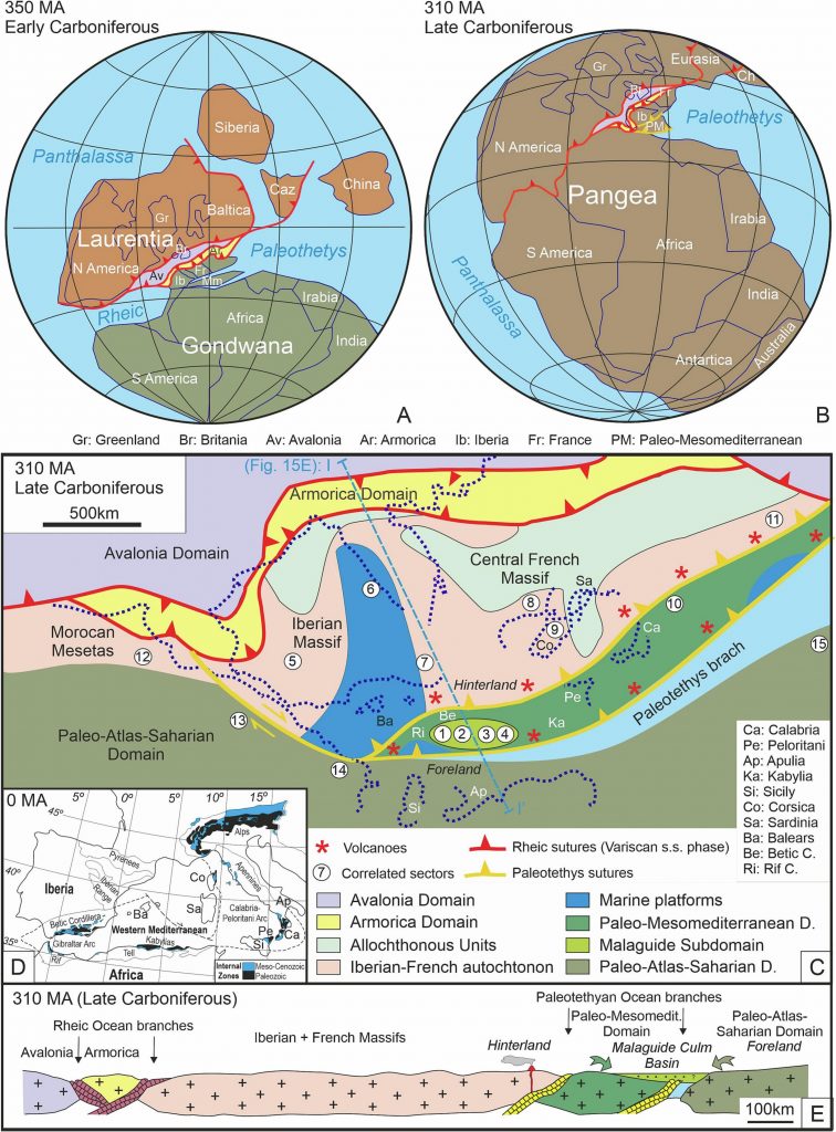
cite as: Criniti, S.; Martín-Martín, M.; Martín-Algarra, A. New Constraints for the Western Paleotethys Paleogeography-Paleotectonics Derived from Detrital Signatures: Malaguide Carboniferous Culm Cycle (Betic Cordillera, S Spain). Sediment. Geol. 2023, 458, 106534, doi: 10.1016/j.sedgeo.2023.106534.
Eocene carbonate platform of the Malaguides of the westermost Tethys
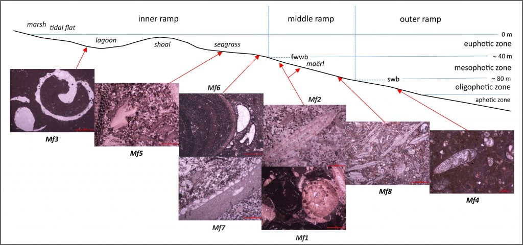
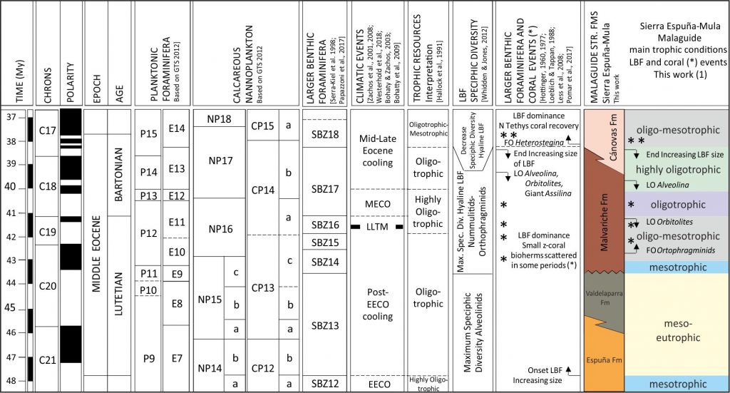
The Eocene Peñicas (Almería) and Harania (Málaga) stratigraphic sections from the Malaguide Complex (Betic Cordillera, South Spain) belonging to the Mesomediterranean Microplate from the westernmost Tethys (about 35◦N) have been studied. The Eocene sections cover the Cuisian to middle Lutetian deposits, which show several lithofacies representing shallow marine platform realms. Based on the fossiliferous assemblage, texture and fabrics, eight microfacies related to inner to outer ramp settings were defined. In the inner ramp of the Harania section abundant colonial corals have been recognized. The Eocene deposits are arranged into a transgressive succession composed by three minor transgressive-regressive sedimentary cycles. The Eocene fossiliferous assemblage shows a mixture of photozoan (Larger Bentic Foraminifera, green and red calcareous algae and corals) and heterotrophic (mollusks, echinoids, bryozoans, small benthic and planktic foraminifers) elements, suggesting euphotic to mesophotic conditions in oligo-mesotrophic marine warm-waters at low-middle latitudes. This assemblage indicates a transition from photozoan to heterozoan carbonates and in particular a shift towards outer marine ramp settings.
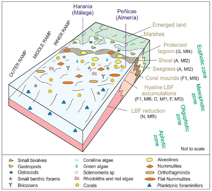
During the Early Eocene, the widespread distribution of Larger Benthic Foraminifera leads in the Tethyan domains to disappearance or extreme reduction of coral constructions. Nevertheless, abundant corals associated to inner ramp realms have been observed in the Harania stratigraphic section indicating that corals could continue to develop in the westernmost Tethys at the transition to the Atlantic Ocean, in contrast with respect to other Tethyan sectors. Therefore, the Ypresian-Lutetian time-span is a transitional period for the global temperature during which corals locally survived only where optimal ecologic conditions occurred, preferably in marginal contexts, as it seems to have happened in the studied area.
Oligocene-Lower Miocene sandstones of Western Tethys
The changing nature of detrital signatures in clastic wedges of the Circum-Mediterranean orogenic systems reflect the provenance relations from different source rocks of evolving geo-puzzle terranes, including ophiolite bearing, uplifted continental crust (both shallow to deep crust terranes), volcanic and sedimentary source rocks. We selected here sandstone suites directly occurring over the Mesomediterranean Micropaleoplate during the final stages of closure of the western-southern Tethyan realm. They are unconformably over the internal domains of the Circum-Mediterranean thrust belts, and include Oligocene-to-lower Miocene siliciclastic formations of the Betic Cordillera (As, Bosque, Río Pliego, El Niño, Ciudad Granada, Fuente-Espejos, Alozaina and Viñuela fms), Rif Chain (Fnideq and Sidi Abdeslam fms), and Calabrian terranes (Paludi, Pignolo and Stilo Capo d’Orlando fms). All these sandstone suites range from quartzolitic to quartzofeldspathic detrital modes reflecting close relations with their Paleozoic metasedimentary and plutonic source rocks and their related Mesozoic sedimentary covers.
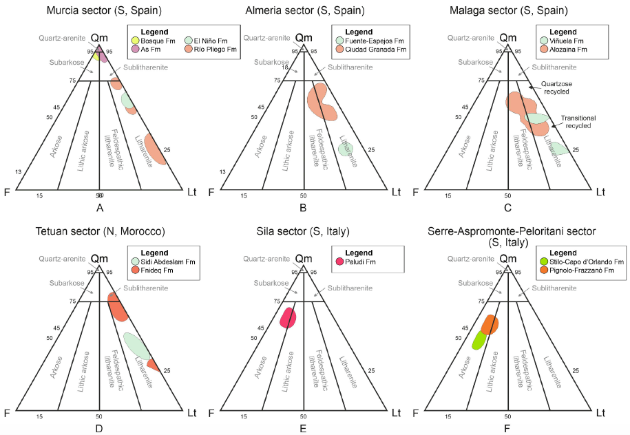
Marked differences have been recognized from western (Betic-Rif) to eastern (Calabria) portions in terms of detritic suites. Detrital suites of the Betic-Rif portions reflect a transition between a craton, transitional and recycled orogenic provenance type. Contrarily, detrital suites of the Calabria portions reflect their transition from transitional continental to basement uplift orogenic provenance reflecting deposition in wedge-top basins during final subduction of the Magrebian-Lucanian-Ionian Basin below the Mesomediterranean and the opening of the Mediterranean basin as a backarc.
The Cenozoic evolution of the Intrarif (Rif, Morocco)
The sedimentary-tectonic evolution of the Cenozoic strata of the El Habt and Ouezzane Tectonic Units (Intrarif, External Rif) in Morocco is presented by a new work by Martín-Martin et al., (2022) in Geosphere.
New data provide information about the depositional architecture and enable a correlation of the evolution of the External Rif in Morocco with that of the Betic Cordillera in Spain and the Tunisian Tell, which provides new insights for hydrocarbon exploration in the region regarding possible source, reservoir, and seal rocks. The reconstructed Cenozoic succession was bio-chronologically defined, and the major unconformities and stratigraphic gaps were identified. The presence of these unconformities allowed three main stratigraphic sequences to be defined by age: Danian p.p., early Ypresian–early Bartonian p.p., and the early Rupelian–early Serravallian p.p. Three secondary stratigraphic sequences in the former upper main sequence were also defined by age: early Rupelian–late Chattian p.p., Burdigalian p.p., and the Langhian–Serravallian p.p. The depositional setting evolved from deep basin during the Late Cretaceous–Paleocene to external platform-slope during the Eocene–Miocene.
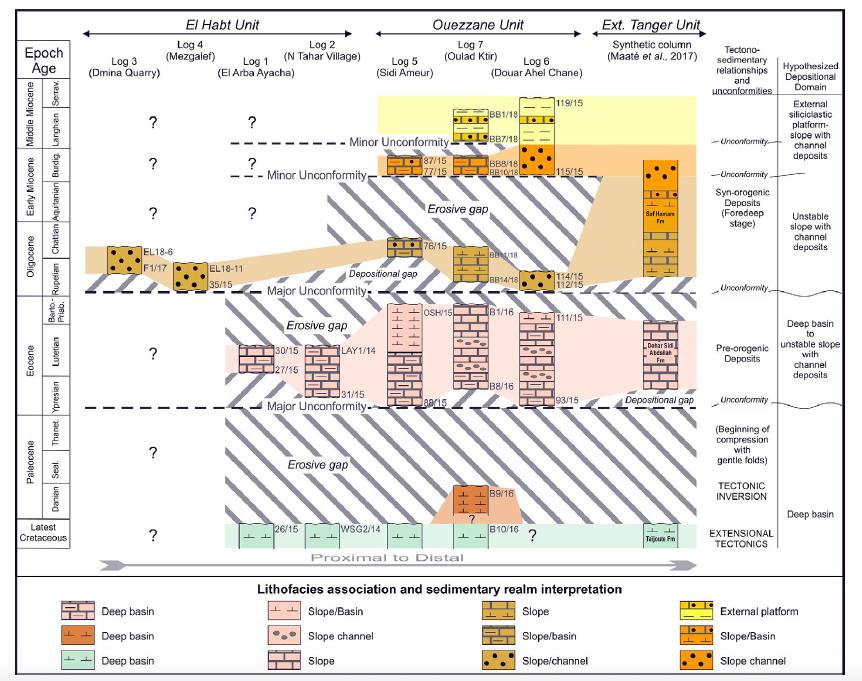
The Cenozoic sandstones contain metamorphic and sedimentary rock fragments derived from a recycled orogen source area. The clay mineralogy in the Cenozoic strata consists of associations of Ill+(I–S) ± Sme, Ill+(I–S) ± Sme+Kln and Ill+(I–S) ± Sme+Kln+ Chl. These associations indicate an initial unroofing in the Paleogene period, then in the Cretaceous period, and finally in the Late Jurassic period during the Eocene–Oligocene. This detritus was followed by variable amounts of a sedimentary mix of Paleogene to Late Jurassic terrains due to several phases of erosion and deposition partly related to syn-sedimentary tectonics during the Miocene. Equivalent features (similar types of sediments, tectofacies, gaps, and unroofing) were also recognized along the Betic Cordillera in Spain and Maghrebian Chain (Morocco and Tunisia) and interpreted as related to a pre-nappe tectonic activity of soft basement folding, which occurred during the Paleogene after the generalized tectonic inversion (from extension to compression) occurred in the Late Cretaceous. The Upper Cretaceous is considered to be the hydrocarbon source rock, while the fractured Eocene and the porous Oligo-Miocene suites are proposed as possible hydrocarbon reservoirs. The Cenozoic stratigraphic architecture and the nappe structure of the region could provide the necessary trap structures.
Terminology revision of AlKaPeCa and Mesomediterranean Microplate
The use of terms strictly related to the original formulation of different models caused, in some cases, inaccuracies in the univocal identification of some main palaeogeographic elements.
Bouillin et al. (1986) introduced the acronym AlKaPeCa for a lithospherical block formed by Alboran-Kabylian-Peloritan-Calabrian Internal Zones, Alpine units. According to them the relationships between AlKaPeCa and the Maghrebian Flysch Basin may be synthesized as follows:‘ the only possible oceanic zone known between Western Europe and Africa, at the Jurassic time, corresponds to the basement of the Flyschs which was located southward of AlKaPeCa’ .
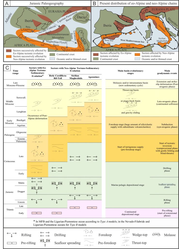
Many palaeogeographic interpretations of the Jurassic-Cretaceous evolution of the Betic, Maghrebian and Apennine Chains have been roughly grouped into two main general families: (1) Type A models: they state the presence of a single oceanic area (i.e., the Tethys) located between the African and European Plates; (2) Type B models: they consider the occurrence of two oceanic branches of the Tethys surrounding one or more microcontinents located between the African and European Plates. Both classes of models imply a different evolution during the Pangea breakup and during the Cretaceous-Cenozoic convergence. According to Type A models the Pangea broke with a single oceanic branch located between Europe and Africa, meanwhile according to Type B models the fragmentation was more complex leading to two oceanic branches with several microplates located between Europe and Africa.
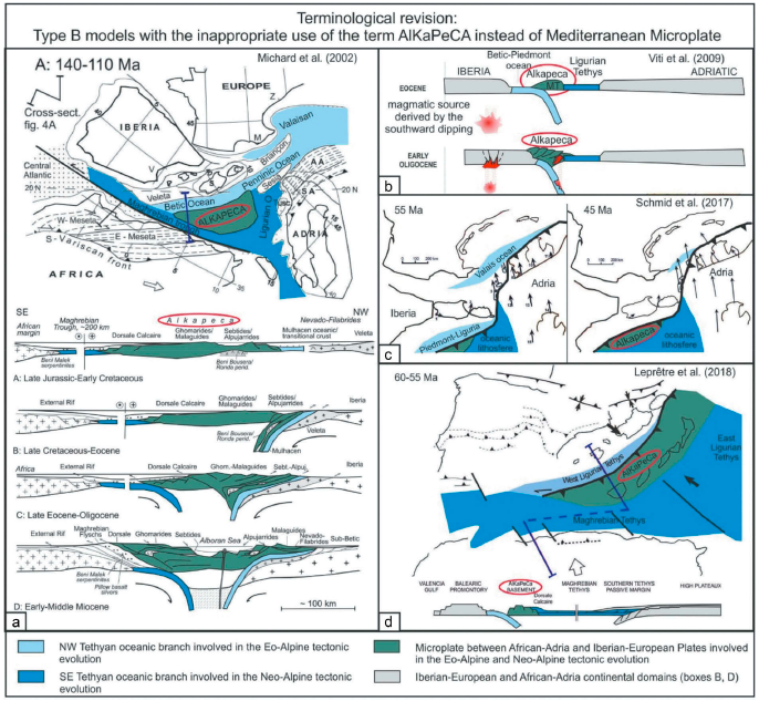
According to Guerrera et al. (2019) the original meaning of AlKaPeCa should be reserved to indicate a detached piece of the European Margin while the Mesomediterranean Microplate should be used exclusively for the independent microplate even though during the Maghrebian- Apennine orogeny these elements actually coincide to form the Internal Zones of these chains. For this reason, the use of this acronym is not appropriate for models which consider the occurrence of an independent microplate surrounded by different oceanic branches of the Tethys since Mesozoic. A more common name used in literature for this microplate is the Mesomediterranean Microplate.
Evolutionary geological models of the central-western peri-Mediterranean chains
Two main groups of geological models presented over the last four decades on the paleogeographic, paleotectonic and geodynamic eo-Alpine and neo-Alpine evolution of the central-western Mediterranean area were compared. The comparison was carried out mainly considering the main stratigraphic, sedimentological, petrographic, structural and plate tectonic constraints. Moreover, recent geophysical interpretations and reconstructions were also considered with an aim of presenting all the different results. The models can roughly be grouped into two main classes. First family considers the presence of the Mesozoic Tethyan Ocean, where a single oceanic basin is located between Africa and Europe and from which both eo-Alpine and neo-Alpine chains were generated during the Cretaceous to Miocene time span. Conversely, the other class considers the occurrence of at least two Tethyan oceanic branches (or with thinned continental crust) since the Jurassic, separated by one or more microcontinents. The pros and cons of both classes of models are presented. Progressive innovations and improvements to the two groups of models were proposed over the years. However, because the modelsare based on different data sets resulting from basic geological studies or obtained by means of other approaches, they often do not integrate easily.This caused interpretative difficulties and terminological uncertainties for their comparison, and completely different models were considered equivalent and, sometimes, the same terminology was used indifferently to identify different geological subjects. The main differences between the examined models concern the kinematic reconstructions and by hence in the paleogeographic and paleotectonic interpretations. The discussion presented in this paper aims at contributing to clarify and update the state of knowledge on this controversial topic.
Recent Comments