Home » Posts tagged 'granulometry'
Tag Archives: granulometry
K-nearest neighbors algorithm used for classifying geological variables.
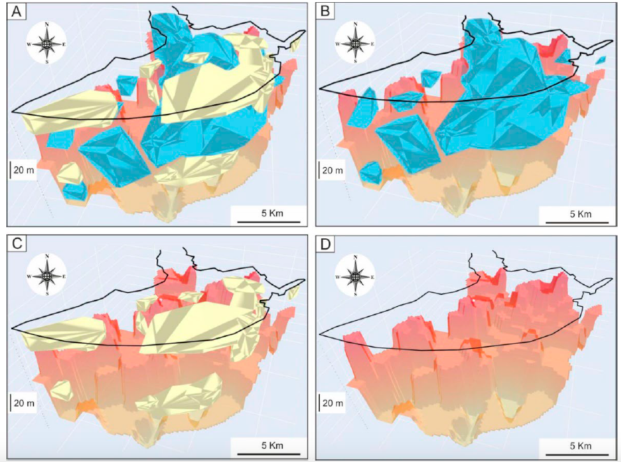
The k-nearest neighbors (KNN) algorithm is a non-parametric supervised machine learning classifier; which uses proximity and similarity to make classifications or predictions about the grouping of an individual data point. This ability makes the KNN algorithm ideal for classifying datasets of geological variables and parameters prior to 3D visualization. This paper introduces a machine learning KNN algorithm and Python libraries for visualizing the 3D stratigraphic architecture of sedimentary porous media in the Quaternary onshore Llobregat River Delta (LRD) in northeastern Spain. A first HTML model showed a consecutive 5 m-equispaced set of horizontal sections of the granulometry classes created with the KNN algorithm from 0 to 120 m below sea level in the onshore LRD. A second HTML model showed the 3D mapping of the main Quaternary gravel and coarse sand sedimentary bodies (lithosomes) and the basement (Pliocene and older rocks) top surface created with Python libraries. These results reproduce well the complex sedimentary structure of the LRD reported in recent scientific publications and proves the suitability of the KNN algorithm and Python libraries for visualizing the 3D stratigraphic structure of sedimentary porous media, which is a crucial stage in making decisions in different environmental and economic geology disciplines.

Interactive figures here
A Python Application for Visualizing the 3D Stratigraphic Architecture
A Python application for visualizing the 3D stratigraphic architecture of porous sedimentary media has been developed. The application uses the parameter granulometry deduced from borehole lithological records to create interactive 3D HTML models of essential stratigraphic elements.

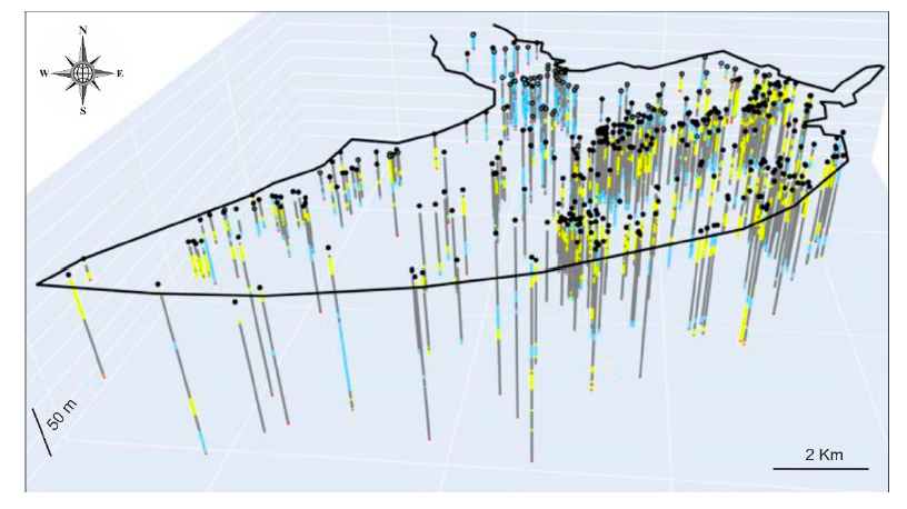
On the basis of the high density of boreholes and the subsequent geological knowledge gained during the last six decades, the Quaternary onshore Llobregat River Delta in northeastern Spain was selected to show the application. The public granulometry dataset produced by the Water Authority of Catalonia from 433 boreholes in this strategic coastal groundwater body was clustered into the clay–silt, coarse sand, and gravel classes. Three interactive 3D HTML models were created. The first shows the location of the boreholes granulometry. The second includes the main gravel and coarse sand sedimentary bodies (lithosomes) associated with the identified three stratigraphic intervals, called lower (>50 m b.s.l.) in the distal Llobregat Delta sector, middle (20–50 m b.s.l.) in the central Llobregat, and upper (<20mb.s.l.) spread over the entire Llobregat. The third deals with the basement (Pliocene and older rocks) top surface, which shows an overall steeped shape deepening toward the marine platform and local horsts, probably due to faulting. The modeled stratigraphic elements match well with the sedimentary structures reported in recent scientific publications.
This proves the good performance of this incipient Python application for visualizing the 3D stratigraphic architecture, which is a crucial stage for groundwater management and governance.
Recent Comments