Deciphering the Eocene carbonate platforms of the Bekrit-Timahdite sector (Middle Atlas, Morocco). This study identifies thirteen sedimentary facies (F1 to F13) across five stratigraphic sections, representing shallow marine carbonate platform environments. These are characterized by lithology, sedimentary structures, and macrofossil content including oysters, gastropods, echinoids, algae, fish remains, and bryozoans. A total absence of larger benthic foraminifera (LBF) and zooxanthellate corals (z-corals) has been noticed. Biostratigraphic analysis dated the basement as Maastrichtian (non terminal) and the Paleogene succession as Lutetian. Eight carbonate platform microfacies (Mf1 to Mf8) were defined, covering both inner ramp (tidal flat, lagoon, shoal, and oyster-rich reef bioherm) and mid ramp (reef slope and open marine) environments. The Eocene fossil assemblage indicates the presence of heterotrophic communities thriving in meso- to eutrophic waters, indicative of a tropical, heterozoan carbonate factory dominated by bryozoans and mollusks. Subsidence patterns varied significantly: Logs 4 and 5 (Folded Middle Atlas Block) recorded higher subsidence rates, while Logs 1 to 3 (Tabular Middle Atlas Block) show lower rates. Succession is organized into low-frequency (3rd-order) predominantly transgressive sequences, typically punctuated by rapid regressions and transgressions. These depositional rhythms are interpreted as responses to regional tectonic pulses associated with the Eo-Alpine phase. Regional correlations reveal a striking contrast: while coeval Neo-Tethyan platforms, from Spain to Italy, are characterized by homogeneity and abundant LBF and z-corals, the study area and the Algerian Saharan Domain, lack these taxa, instead featuring sediments rich in phosphates, oysters, and fish remains. This distinctive facies association (heterozoan dominated) reflects nutrient-rich upwelling zones similar to those in the Atlantic. It is proposed that further exploration of a potential narrow corridor, which served as hinterland to the Atlas-Mesetas System during the Paleocene-Eocene period and was influenced by tectonic controls from basement folding, could elucidate the origin of these Atlantic-type deposits.

Cite as: Martín-Martín, M., Tosquella, J., Miclăuș, C., Maaté, A., Tent-Manclús, J. E., Maaté, S., Monteil, E., Serrano, F., Martín-Pérez, J. A. (2026): Deciphering the Eocene carbonate platforms of the Bekrit-Timahdite sector (Middle Atlas, Morocco): The gateway to the Atlantic Domain. Sedimentary Geology, 496, 107055. https://doi.org/10.1016/j.sedgeo.2026.107055
Tags: Atlantic domain, carbonate platforms, Eo-Alpine tectonic phase, Oyster reef, Paleoenvironmental evolution
Three of the top cited paper, the first one, Criniti et al. (2023), the fourth one, Martín-Martín et al. (2023a), and the seventh, Martín-Martin et al., (2023b), have been written by our group, and have been referred in this blog.
Tags: eocene, Sedimentary Geology
Interactive 3D HTML models and visualizations of geological structures derived from classic surface geological information have been developed, for the first time, in a Python environment, using the key case of the tectonic Mula sheets in the Betic Cordillera (southern Spain). These models were performed through several steps: a geological 2D sketch map, creating equispaced geological cross-sections, 3D topography, a complete 3D model, and detailed 3D block diagrams. The result of the extrapolation of the equispaced geological cross-sections and their integration with the geological map into a 3D geological model shows the thrust-faulted and contractionally folded structure of the entire area, which affects the Cretaceous to Lower Miocene succession. The faults (strikeslip and normal) present in the tectonic thrust sheets are also represented. Three detailed 3D HTML blocks of illustrative regions within the modeled area were also created. For the 3D modeling, Bézier curves/surfaces as well as linear interpolation were used, as geological (stratigraphic and tectonic) contacts and surfaces between different stratigraphic units can be expressed geometrically with these tools. Compared to commercial alternatives, our software offers three key advantages: free user-friendly solutions, browser-compatible 3D models, and open-source software. The 3D visualization of stratigraphic-structural architecture enables predictive interpretations with applications in environmental and economic geology (e.g., groundwater, geotechnical studies, mining research, etc.). Moreover, 3D visualization and modeling provide valuable insights into geological phenomena, benefiting both the scientific community and society at large. Furthermore, advances in interactive 3D visualization bridge the gap between cutting-edge geological research and public understanding, enhancing social awareness.
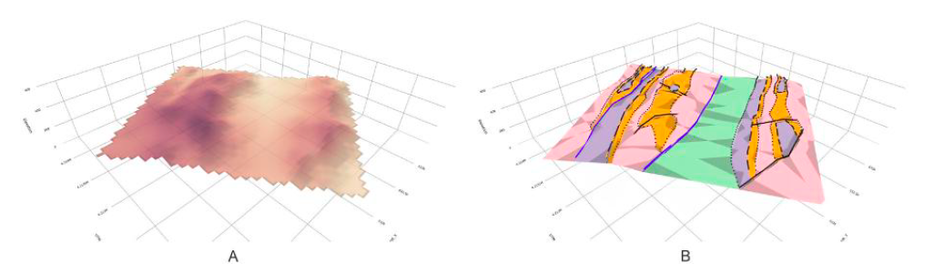
Three-dimensional topographic representations of the Mula sheets area showing: (A) the interpolated digital elevation model surface generated from point grid data using linear interpolation, and (B) the complete geological 3D map with real topography where stratigraphic units (Cretaceous C1-C2 in green, Paleocene P in violet, Eocene E1-E2 in orange-pink) are draped over the topographic surface, with thrust faults displayed in blue and normal faults in black.
Cite as: Bullejos, Manuel, and Manuel Martín-Martín. 2025. 3D Modeling and Visualization of Geological Structures with Python-Implemented Bézier Curves/Surfaces. Journal of Structural Geology 200: 105508. https://doi.org/10.1016/j.jsg.2025.105508.
Tags: Bézier curves/surfaces, Geological 3D HTML models, Linear interpolation., Python environment
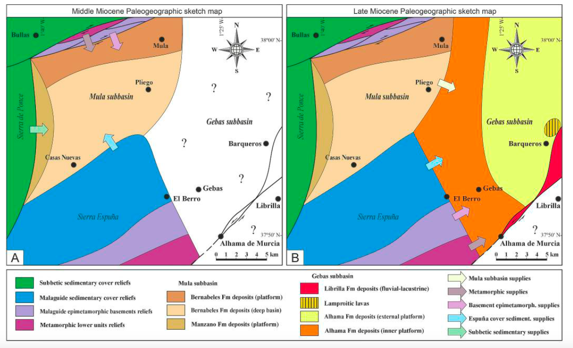
The Sierra Espuña and the Mula-Gebas intramontane basin, SE Spain, represent the Internal-External Zone Boundary (IEZB) of the Eastern Betic Cordillera. The Miocene infill of this basin seals the IEZB and is mainly derived from the Internal Zone. This deposition is coeval with a Late Miocene volcanism. Therefore, the study of these sediments is crucial for the source-area provenance, sorting and recycling, paleoclimate, weathering, unroofing and tectonic processes, during the intramontane basins developing of the western peri-Mediterranean Chains. Sandstone detrital modes, and mineralogical and chemical compositions of mudrocks were arranged in two sedimentary cycles: (1) the Middle Burdigalian-Early Langhian, and (2) the Middle Tortonian-Early Messinian. The quartzolithic to feldspathic lithoarenites infer the erosion from a lithic-transitional recycled to transitional-quartzose recycled orogen, since low-medium grade metamorphic lithics and rare coeval volcanics with andesitic, andesitic-dacitic and rhyodacitic-rhyolitic sources are present. The mudrocks reveal a felsic (granitic-gneiss) source with a minor mafic input in the Upper Miocene. A shallow burial history and low thermal conditions (<~50 ◦C) has been also evidenced. Moreover, the paleoclimate changed from warm and/or wet during the Middle Miocene to cold/arid in the Late Miocene.
cite as: Perri, Francesco, Sara Criniti, Francesco Cavalcante, Manuel Martín-Martín, Antonio Sánchez-Navas, and Salvatore Critelli. 2025. “The Miocene Sedimentary Cover of the Mula-Gebas Basin: Internal-External Zone Boundary of the Betic Cordillera, South Spain.” Sedimentary Geology 486: 106924. https://doi.org/10.1016/j.sedgeo.2025.106924.
Tags: Basement unroofing, intramontane basins, Paleoclimate, provenance
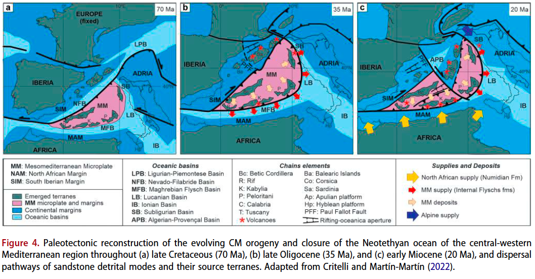
According to classical literature, two Paleogene platforms developed along the northern and southern margins of the Neo-Tethys Ocean. Similar platforms have been recognized on the southern margin of a “lost domain” consisting of an independent microplate known as the “Mesomediterranean Microplate” (MM) in the westernmost Neo-Tethys Ocean. This microplate underwent tectonic dismantling and drifting during the opening of the western Mediterranean. The individualized blocks collided with the European and African palaeomargins during the Miocene, forming the Neo-Alpine chains of the western Mediterranean. The regional reconstruction and lateral correlation of Paleogene deposits have provided valuable insights into the paleogeographic and geodynamic evolution of this lost domain. The most representative Paleogene successions lie unconformably over the Palaeozoic basement and Mesozoic sedimentary cover. The sedimentary evolution, source areas, peleoclimate and palaeoenvironments recognized along the Betic and Maghrebian (Rif, Tell, Calabria-Peloritani Arc) chains have also been compared. Reconstructions of the MM using GPlates software have placed the original position of these platforms approximately at 30◦ N, and between 5◦W and 10◦E. Along the southern border of this microplate, a northward transition towards continental areas and a southward transition into deeper marine domains were identified. Additionally, distinctions were made between areas with complete Paleogene successions and those with condensed successions, as well as between carbonate-dominated and siliciclastic-dominated platforms.
Tags: Mesomediterranean Microplate, Paleogene, Peri-Mediterranean chains, Tectono-sedimentary evolution
Early Jurassic multicostate Terebratulida are substantiated in the Subbetic Domain and reported in the Iberian Range for the first time. Records of this clade are revised in the peri-Iberian platforms (Subbetic, Iberian Range, Gibraltar, North and NE Spain, Lusitanian basin) in order to evaluate their global pattern distribution across the Tethys Ocean. After a new tectonosedimentary analysis, marine swells are proposed as depositional scenarios for the assemblages containing Hesperithyris aff. sinuosa in the southernmost Subbetic paleomargin, sheding light to the intrincate paleogeography of this part from the Betic Range. In the Iberian Range, the same species and Merophricus ? fimbrioides occurred in extensive flooding intervals arriving from the deepest marine populations. As results of taxonomic and paleobiogeographical analyses, two morphotypes, Merophricus – and Hesperithyris -type, are discriminated forming part of the westernmost Tethys migration route. It can be ascertained that their E-W Tethyan spreading was fulfilled for the Merophricus -type from the intra-Mediterranean basins to the westernmost arc of the Tethys Ocean, via the Betic–Gibraltar seaway, reaching the proto-Atlantic northwards (Lusitanian basin) and possibly the northern margin of the Iberian Massif and Western France. In contrast, Hesperithyris aff. sinuosa from the Iberian and Betic ranges correspond to the intra- and peri-Mediterranean Hesperithyris– type, with a different dispersal pattern. The only Lower Jurassic Hesperithyrys -type multicostate terebratulides reported in the boundaries of the NW-Boreal bioprovince derive from the Northeastern Iberian paleomargins, probably due to sporadic incursion events at transgressive episodes. The row of Subbetic epioceanic seamount stepping stones helped the Merophricus -type migration in the E-W Mediterranean route and their pivotal position facilitated the dispersal of both morphotypes via the epicontinental Iberian seaway. In the Subbetic, the Hesperithyris bearing assemblages are recorded in the Pliensbachian Lavinianum Zone (Portisi and Cornacaldense subzones) equivalent to the basal part of the Margaritatus Zone (Stokesi Subzone) from the Iberian Range where the same species is now recorded, thus correlating the Southern epioceanic paleomargins with the Eastern epicontinental platforms. The origin and dispersal of the Merophricus -type around the Si–Pl boundary concurred with the Western Tethys early pre-rifting stage, and the pre-Domerian drowning of Tethyan platforms is synchronically consistent with the origin and spreading of the Hesperithyris -type.
Tags: brachiopods, Early Jurassic, Hesperithyris, multicostate terebratulides
The Koudiat El Madene Unit (Arba Massif) belongs to the Kabylian “Dorsal” (Algerian Internal Zone). The stratigraphy and tectonic structuring of the area is equivalent to the western Moroccan Internal Rif and its counterpart in the Spanish Internal Betic Cordillera. In fact, all these chain segments are due to a common Cenozoic geodynamic evolution related to the closure of the westernmost Tethys and the later opening of the Mediterranean Sea. Nevertheless, a comparison of the Kabylian internal units at the western Mediterranean scale was still missing. This study means a revisiting of the outcrops of the Koudiat El Madene Unit and a revision of the existent literature on the area aimed to a comparation of this area with the Algerian Kabylian “Dorsal” and with the Ghomaride (Moroccan Rif) and Malaguide (Spanish Betic Cordillera) equivalents units. This unit crops out in a tectonic window under different backthrusting units of the Maghrebian Flysch Basin Zone and overthrusts southwards the Maghrebian Flysch Basin Zone itself and the External Tellian Zones. This is a frequent tectonic situation of this kind of units in the internal Rif-Betic chains. The condensed succession of the Koudiat El Madene Unit, separated by unconformities but also by internal erosive boundaries, is divided into five stratigraphic formations. Nowadays, the stratigraphic division and dating of the Koudiat El Madene Unit (Algerian Kabyle Unit) are less detailed than its equivalents in the Ghomarides, especially those of the Malaguides. Nevertheless, a correlation with the Ghomaride Units from the Tetouan-Chaouen area (Northern Morocco) and the Malaguide Complex from the Sierra Espuña area (Southeastern Spain) has been performed revealing great similarities. The good correlation can be due to a close paleogeographic position in the southern margin of the Paleo- and Mesomediterranean Microplate. Minor variations should be proposed in relation to the position in the margin. Detailed and modern stratigraphic and sedimentological studies are required to propose a more precise paleogeographic framework.
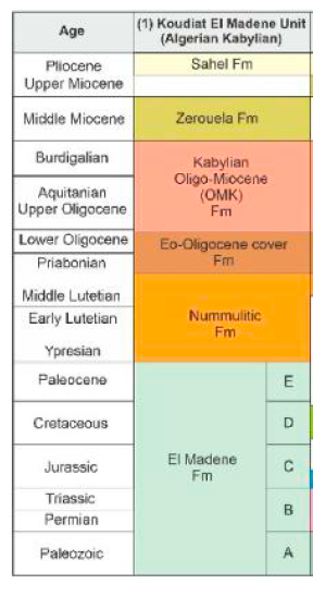
Koudiat El Madene Unit (Algerian Kabylian),
Tags: Algerian Tell, Alpine evolution, Betic-Rif Cordilleras, Internal units, regional correlation
A broad region of Mesozoic to Cenozoic tectonism along the western and central Circum- Mediterranean (CM) margins, from southern Spain (Betic Cordillera) to the northern Morocco (Rif) and Italy (Apennines), includes huge volumes of sedimentary record since the Late Paleozoic. These sediments are contemporaneous and related with the fragmentation of the Pangean supercontinent due to the rifting and progressive closure, as well as the following birth of the CM orogeny. The composition and stratigraphic relations of clastics in diverse sedimentary basins of the CM region reflect a complete record of provenance relations related to the progressive destruction of the Neotethyan Ocean and plate convergence between the two major plates of Europe and Africa, and Iberia, Adria and Mesomediterranean microplates located between them. The changing nature of clastic wedges reflects the provenance relations from different source rocks involving obduction of the oceanic lithosphere, the uplifted Alpine-Mediterranean Chains, and the accreted previously deformed Mesomediterranean Microplate (AlKaPeCa), as well local neovolcanic sources, within the spatial and temporal evolving geo-puzzle terranes of the CM orogeny. The provenance evolution of sediment provides insights into how plate convergence and continental collision direct the sediment dispersal pathway in Cenozoic basins due to closure of eastern and southern Alpine-Tethyan remnant ocean basins and to the dual dispersal pathways from the previously born Alps and the nascent AlKaPeCa at the expenses of the previously deformed Mesomediterranean terranes. The source-to-sink relations testify episodic deformation events, diachronous Tethyan basin development, differentiate sediment provenance from exhumed and uplifted Alpine and CM orogens, and palaeogeographic rearrangement of crustal blocks along the nascent Mediterranean region.
Tags: detrital modes, Paleogeography, Paleotectonics, source-to sink analysis, Western Tethys Ocean
In the Betic-Rif Cordilleras, recent works have evidenced the existence of well-developed Eocene (Ypresian-Bartonian) carbonate platforms rich in Larger Benthic Foraminifera (LBF). Contrarily to other sectors of the western Tethys, like the Pyrenean domain in the North Iberian Margin, where these platforms started in the early Ypresian (Ilerdian), in the Betic-Rif chains, the recorded Eocene platforms started in the late Ypresian (Cuisian) after a widespread gap of sedimentation including the Ilerdian time span. In this work, the Aspe-Terreros Prebetic section (External Betic Zone) is studied. An Eocene succession with gravity flow deposits consisting of terrigenous and bioclastic turbidites, as well as olistostromes with olistoliths, was detected. In one of these turbidites, we dated (with the inherent limitations when dating bioclasts contained by gravity flow deposits) the middle Ilerdian, on the basis of LBF, representing a vestige of a missing Illerdian carbonate platform. The microfacies of these turbidites and olistoliths rich in LBF have been described and documented in detail. The gap in the sedimentary record and absence of Ilerdian platforms in the Betic-Rif Cordillera have been related to the so-called Eo-Alpine tectonics (Cretaceous to Paleogene) and sea-level variations contemporarily with the establishment of shallow marine realms in the margins of the western Tethys.
Tags: lost Ilerdian carbonate platforms, microfacies, Prebetic, South Iberian paleomargin
The march issue of the Geoscience journas has a cover story dealing with the newly published paper in that issue by Tosquella et al. (2025) of our group. In the Betic-Rif Cordilleras the Eocene platforms started in the Cuisian after a gap including the Ilerdian. An Eocene succession with gravity flows consisting of turbidites and olistostromes was detected in the Aspe-Terreros Prebetic section (External Betic Zone). In one of the turbidites, we dated the middle Ilerdian, on the basis of LBF, representing a vestige of a missing Illerdian carbonate platform. The microfacies of these deposits rich in LBF have been described and documented. The gap in the sedimentation and absence of Ilerdian platforms in the Betic-Rif have been related to the so-called Eo-Alpine tectonics (Cretaceous to Paleogene) and sea-level variations contemporarily with the establishment of shallow marine realms in the western Tethys.
Tags: eo-alpine tectonics, lost Ilerdian carbonate platforms, microfacies, Prebetic, South Iberian paleomargin
Recent Comments