Thirteen Paleocene-Eocene sections have been studied along the Prebetic Domain (South Iberian Margin) in the Alicante, Murcia, Granada, and Jaen Sectors. The sedimentary realms (mostly consisting in 15 shallow marine Lithofacies) and the tectono-sedimentary evolution were characterized. Three informal stratigraphic units were proposed and dated with planktic foraminifera, calcareous nannoplankton, and Larger Benthic Foraminifera (LBF): (1) lower marly-clayey fm; (2) intermediate limestone-calcarenite fm; and (3) upper marly-clayey fm. The stratigraphic architecture shows diachronous boundaries and lateral passages, representing the internal and external platform (upper slope in a few cases). The lower marly-clayey fm is upper Paleocene to middle Lutetian, the intermediate limestone-calcarenite fm ranges from lower Ypresian to lower Bartonian, while the upper marly-clayey formation is lower Lutetian to lower Priabonian. The diachronism can be due to the inherent sedimentary paleoenvironment changes and to climatic-tectonic interferences. The noticeable thickness variations of sedimentary successions in the studied sections could indicate a synsedimentary tectonics with upward and downward movements of blocks or folds. During the Paleocene-Eocene, the studied area was part of the meridional belt of platforms in the western Tethys. A comparison with other sectors of the central-western Mediterranean area has been performed to evidence synchronous events at Tethyan scale. The compared margins experienced a common pre-foredeep evolution affected by the Eo-Alpine tectonics (Cretaceous to Paleogene) contemporaneously to the establishment of shallow and deep palaeoecological realms. In the case of shallow sedimentary successions, LBF and corals are registered. Comparable gaps in sedimentation are recorded in most of the correlated domains.

Tags: carbonate platform, Paleocene-Eocene, Prebetic, South Iberian paleomargin
The Carboniferous detrital suites of the Ghomaride Subdomain (Rif Cordillera, N Morocco) has been undertaken in order to obtain paleogeographic and paleotectonic constraints. Microconglomerate and sandstone samples from eight sections belonging to four sectors were petrographically studied. This northern Gondwana domain was part of the Paleo-Mesomediterranean Plate, located between the Iberian-French Plates and the African Paleo-Atlas-Saharian Domain, which outlines a gap of knowledge since these domains are now part of the Alpine peri-Mediterranean chains. Part of this data-lacking is related to the sandstone detrital modes that have never studied in this area, allowing to obtain information about provenance derived from growing orogens, as well as orogenic processes, and tectonic, climatic and/or erosional events. The study has revealed that the sandstones are litharenites to feldsphatic litharenites, evolving upward to lithic arkoses, and has evidenced a quartzolithic petrofacies with a transitional recycled orogen provenance. The metamorphic clastic detritus displays a low to middle-upper metamorphic rank upwardly referred to a subducted terrane. Serpentinite-like detritus indicates a metamorphosed oceanic crust being dismantled. A supply from the Rheic Ocean seems improbable since it was very far and beyond the Iberian Plate. Therefore, closer oceanic sutures should be proposed, probably separating the Paleo-Mesomediterranean Plate from the Iberian-French Plate and from the Paleo-Atlas-Saharian Domain. The syn-sedimentary volcanic activity (felsic to mafic) reinforces the idea of subductions. A correlation with other Culm successions of the western Paleotethys has allowed the performing of a paleogeographic-paleotectonic model during the Paleotethysian tectonic phase, in which the studied sandstones were deposited in a foredeep connected northward with limestone platforms and with a crystalline emerged domain (hinterland-orogenic front: Iberia-French Plate and part of the Paleo-Mesomediterranean Plate) and transitioning southward to an oceanic branch of the western Paleotethys, and finally with the Paleo-Atlas-Saharian band acting as passive margin in the foreland.

A) Paleogeographic sketch of the western Mediterranean area during the late Cretaceous (after Guerrera and Martín-Martín, 2014) with the location of the Mesomediterranean Microplate (in brown color) and the Ghomaride subdomain (in yellow color) as well as the Malaguide, Kabylide, Calabria-Peloritani and Tuscany domains; B) sketch map with the location of the Internal Zones of the Western Perimediterranean Alpine chains (in brown color) derived from the Mesomediterranean Microplate in the left figure. The outcroppings of the Ghomaride subdomains in the Rif Cordillera (in yellow color) are also positioned.
Tags: Carboniferous detrital suites, Culm cycle, N Gondwana plate tectonics, Paleo-mesomediterranean plate
According to the prevailing view in literature, two Eocene carbonate platform belts developed on northern and southern margins of the Tethys Ocean. However, Eocene platforms in the Malaguide −Ghomaride Units (Betic-Rifian Arc; Spain and Morocco, respectively) in intermediate position to the classic platform belts have been proposed in recent literature. A number of representative Ypresian to Priabonian stratigraphic sections have been revisited and empowered by new data collected for the scope. Ten lithobiofacies (consisting of limestones rich in Larger Benthic Foraminifera (LBF), algae, and corals) and ten microfacies (based on fossil assemblage and their relative abundance, texture, and fabric) were proposed for this intermediate platform belt. The paleoenvironmental reconstruction indicate inner to outer ramps (locally also the upper slope) arranged in two sedimentary sequences rich in LBF and corals. A great development of carbonate seagrass factories in most of the areas in which inner ramps developed has been identified. These factories correspond to a warm-temperate system with warm-water conditions mainly in low latitude settings. Trophic resources proposed in these works suggest oligo- to mesotrophic conditions in inner to mid ramp settings, which only evolve to eutrophic conditions in outer ramp and upper bathyal settings. A comparison of the three belts of carbonate platforms at the western Tethys scale has been performed, providing several important constraints in terms of the recorded time period according to the literature, tectonics, transgressive−regressive trendings, relative abundance of fossils, and paleoenvironmental conditions.

Environmental microfacies distribution for the Eocene marine Malaguide−Ghomaride Domains (modified from Maaté et al. 2000; Martín-Martín et al. 2020, 2021, 2023c; Tosquella et al. 2022). Ramp subdivision is based on Burchette and Wright (1992), while photic zones are modified from Pomar (2001); the new considered ‘mesophotic zone’ (zonation by Hottinger 1997) lies between the lower limit of occurrence of marine vegetation and the last occurrence of Larger Benthic Foraminifera, approximately coinciding with the storm wave base (swb). Key: Mf1, inner ramp lagoon, upper subtidal environment; Mf2, shoal, upper subtidal environment; Mf3, inner ramp seagrass, euphotic upper subtidal environment; Mf4, inner ramp coral-foralgal and acervulinid mounds, euphotic environment; Mf5, transgressive lag deposits in the transition between inner-to-mid ramp, euphotic to mesophotic environment; Mf6, mid ramp foralgal packstone–rudstone, mesophotic ma.rl environment; Mf7, proximal mid ramp LBF accumulations (nummulitids) in a mesophotic environment; Mf8, distal mid ramp LBF accumulations (orthophragminids) in a mesophotic to oligophotic environment; Mf9, outer ramp, oligophotic environment; Mf10, aphotic slope environment.
The Eocene platforms of the westernmost Tethys show a lacunose geological record registered from upper Ypresian (Cuisian) to Bartonian. It shows an important gap at the upper Ypresian (Cuisian)−Lutetian boundary. LBF remained the primary framework builders elsewhere until the Bartonian age, with zooxanthelle−coral build-ups playing a more significant role in the inner ramps than previously assumed.
Cite as: Martín-Martín, M., Tosquella, J., Guerrera, F., Maaté, A., and Martín-Algarra, A. (2024). The Eocene carbonate platforms of the westernmost Tethys: a review. International Geology Review, 1-33. https://doi.org/10.1080/00206814.2024.2397804
Tags: Betic-Rif Cordilleras, carbonate platforms, larger benthic foraminifera, Paleoenvironmental evolution, westernmost thetys
A model of the Cenozoic tectono-sedimentary evolution of the External Rif Chain (Morocco) is provided by means of the study of the mineralogical and geochemical composition of mudrocks. To date there was a lack of homogeneous data and of a complete and extensive study of the whole External Rif Zone (ERZ). Therefore, this work shows the study of the whole ERZ where the most representative stratigraphic sections have been selected. This work provides important information about the geodynamic evolution and the variations in source-area provenance related to the growing of the Rif orogenic belt. Although there is still much work to be done, this study aims to improve the knowledge of the Cenozoic tectono-sedimentary evolution of the entire western ERZ with a homogeneous method, with a focus on the paleogeographic and paleotectonic evolution, the paleoweathering and the source areas deduced from mineralogical and geochemical data of the Cenozoic mudrocks. The bulk mineralogy is mainly characterized by the presence of calcite, quartz and dolomite plus ankerite. Feldspars have few percentages.
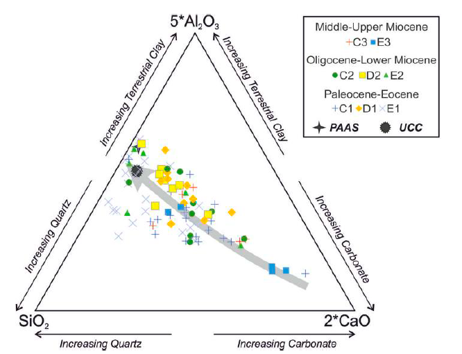
Ternary diagram of SiO2-5*Al2O3-2*CaO of the studied mudrocks. UCC (Upper Continental Crust; McLennan et al., 2006) and PAAS (Post- Archaean Australian Shales; Taylor and McLennan, 1985).
The clay minerals are principally represented by mixed-layer illite/smectite (I/S). Illite and kaolinite are in little amount. Femic minerals, mixed-layer chlorite/smectite (C/S) and chlorite are the most abundant. The I/S features suggest a different thermal condition for the three domains. The chemical composition indicates that the mudrocks can be described as mixtures of carbonates with aluminosilicate components. The Al/Ti, Th/Cr, Th/Sc, La/Th and La/Sc ratios, the Cr/V vs. Y/Ni plot, the V-Ni-Th*10 and La-Th-Sc ternary diagrams indicate a predominantly felsic source with a minor mafic input more evident in the Paleocene-Eocene samples of the External Intrarif and Mesorif. The External Rif Zones changed in the Cenozoic from a passive margin to a complex foreland system with the incoming of the Alpine tectonic phases. In general, the felsic contribution should be linked to the foreland area consisting in the Middle Atlas and Mesetas massifs made of a crystalline domain. This margin probably presented an intermediate narrow oceanic branch in the External Intrarif-Mesorif boundary that surprisingly should start to close during Paleogene times providing the mafic contribution. This Paleogene tectonic activity in these domains is corroborated by the thermal maturity indicating late diagenesis. The chemical weathering indices, such as the CIA (Chemical index of Alteration) and its modifications, show medium-high values and thus suggest generally moderate paleoweathering conditions in agreement with the predominant amount of I/S.
cite as: Perri, F., Cavalcante, F., Martín-Martín, M., Sánchez-Navas, A., Alcalá, F.J., 2024. Cenozoic tectono-sedimentary evolution of the external rif chain (Morocco) derived from mineralogical and geochemical analysis of mudrocks. Mar. Pet. Geol. 170, 107124. doi: 10.1016/j.marpetgeo.2024.107124
Tags: climate and tectonic conditions, diagenesis, provenance, weathering
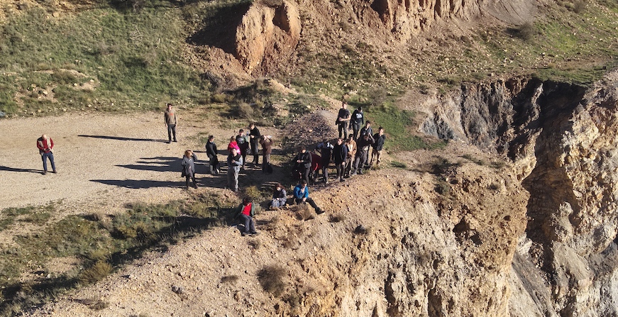
Students of the third course of Geology of the Alicante University within the subject of Regional Geology: visit the abandon Ojos Negros quarry. This is an excellent Ordovician-Silurian section of the Hirnantian glaciation.
The picture shows the student at the quarry border.
Tags: field trips, Ojos Negros, Ordovician, Teruel
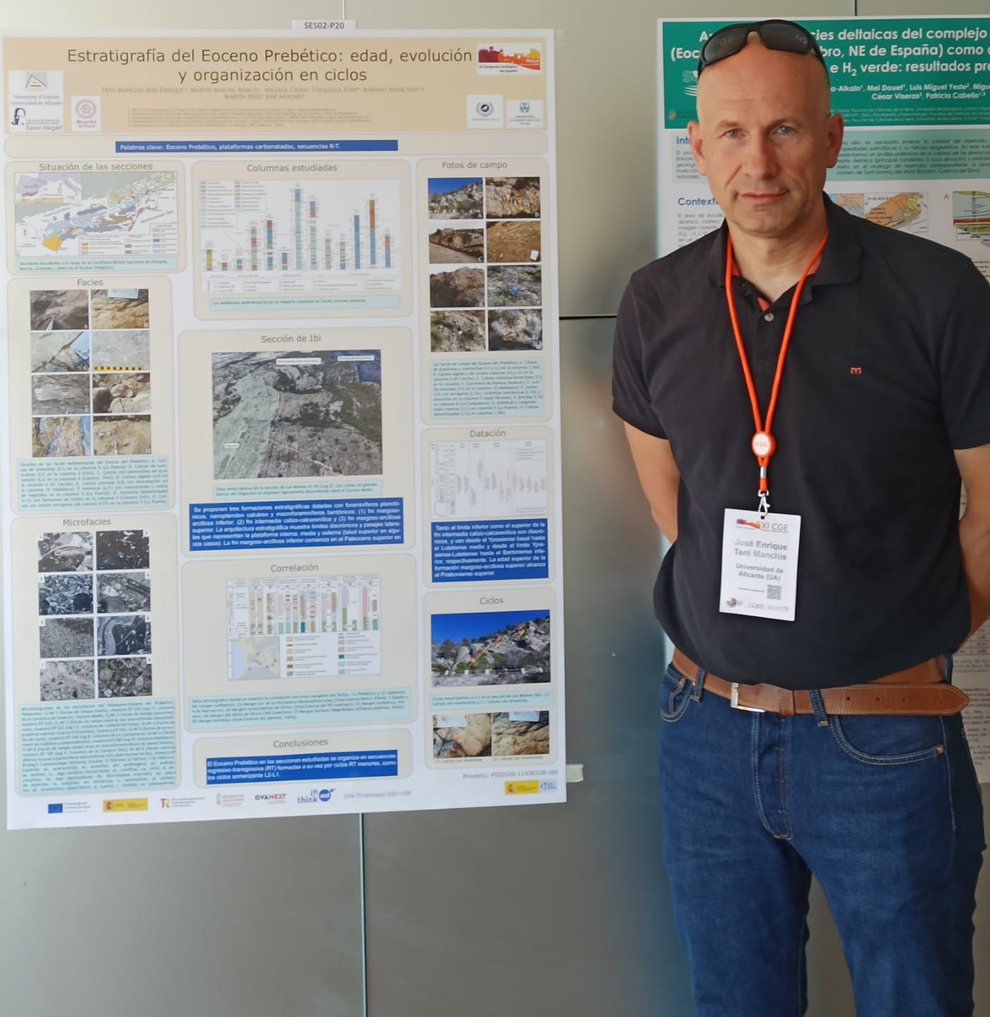
A paper on geological cycles during the Eocene in the Prebetic (SE Spain) was presented at the XI Spanish Geological Congress held Ávila (Spain) from July 1 to 6, 2024. The picture show the poster and the participant José Enrique Tent-Manclús.
The Miocene evolution of the External Rif Zone (NW Africa Plate) was determined through multidisciplinary analysis of fourteen successions. The updated stratigraphic framework shows how Miocene sediments rest on the Cretaceous–Paleogene terrains through unconformity surfaces, whereas it rests with sedimentary continuity in two sectors. After recognition of lithofacies and three unconformities located near the Oligocene–Aquitanian, Aquitanian–Burdigalian and Serravallian–Tortonian boundaries, the Miocene sedimentary record was divided into three stratigraphic intervals representing deep to shallow marine deposits as Aquitanian–Burdigalian, Langhian and Upper Serravallian–Missinian. The two oldest unconformites are restricted to the central sector, while the upper one is generalized and probably related to the nappe tectonics registered in all sectors of the External Rif. Data from analysis of tectofacies, petrology, mineralogy, meaning and implications of unconformities, and subsidence indicate that: (i) mass flow deposits (turbidites, slumps, olistostromes) are common in all successions but more frequent during the Lower Miocene; (ii) petrology of the detrital components of the arenites indicates recycled orogen-derived sediments, with quartz coming from erosion of metamorphic rocks of the Atlas orogen and/or the African craton; (iii)mineralogy of mudstones suggests a complex erosional evolution of local emerged areas derived from a mixture of contributions coming from the erosion of Upper Jurassic to Paleogene suites, and especially from kaolinite-rich Albian–Cenomanian to Paleogene successions with absence of a clear unroofing.
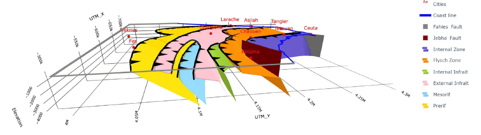
Display of the 3D structural model performed with Python codes; see file 3D_ZER_structural_model.HTML
The conjunction of all these clues reinforces the idea of a synsedimentary tectonics affecting themargin/basin system during the Miocene. A thickness analysis of the studied sedimentary successions allows proposing the evolution of the orogenic front and main depozones (foredeep, bulges, wedge-top and intramontane sub-basins) integrated in a complex foreland system migrating from north to south with the Atlas-Mesetas area acting as foreland during Miocene. The orogenic front moved from the Internal Intrarif to Mesorif and later to Internal Prerif. The main wedge-top basin also migrated from the Internal Intrarif to External Intrarif. The foredeep migrated from the Mesorif to the Internal Prerif,while the main forebulge was located in the External Prerif and a secondary bulge developed in the External Intrarif. Intramontane basins developed behind the orogenic front in relative extensional conditions moving from the Internal Intrarif to External Intrarif. The reconstructed Miocene evolution was inserted into a 2D paleogeographic geodynamic evolutionary model using GPlates software, and then compared to those reported in other external margins of the western Tethys (Betic Chain, Tunisian Tell, Sicilian Maghrebids and Apennines), revealing important similarities and local differences.
Tags: foreland basins system, Maghrebian Ocean margins, Miocene, Tectono-sedimentary evolution, Western External Rif
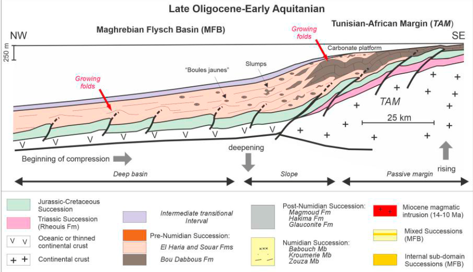
A review of the paleogeographic and tectonic reconstruction of the onshore and offshore Tunisian margin during the Cenozoic is discussed. Five unconformities (A to E) and associated stratigraphic gaps of various vertical extents allow subdivision of the stratigraphic record into depositional units in the following time intervals: (i) Paleocene-Oligocene, (ii) Oligocene-early Aquitanian, (iii) early Aquitanian-Burdigalian, (iv) late Burdigalian-Langhian and (v) Langhian-late Miocene. These intervals can in turn be grouped into four main sedimentary cycles (SC1–SC4) dated to the (1) Paleocene-Oligocene, (2) Oligocene–Burdigalian, (3) Burdigalian-Langhian and (4) Langhian-late Miocene. The oldest depositional unit reflects Eo-Alpine tectonics in the Maghrebian Flysch Basin (MFB); the others are related to the Neo-Alpine syn- and late orogenic tectonic deformation affecting the MFB. The uppermost unit represents post-orogenic deposition. Early Miocene synsedimentary tectonism led to (1) deposition of thick successions owing to a large sediment supply and (2) the occurrence of various tectofacies (unconformities, slumps, mega-turbidites, olistostromes, growth folds, chaotic intervals and heterogenous lithofacies), that all, together with the occurrence of lateral change of facies, clearly indicate non-cyclical sedimentation. During the middle Miocene the Tunisian Tell underwent polyphase thrust tectonism, followed by late Miocene strike-slip deformation with contemporaneous rejuvenation of halokinetics and magmatism (the La Galite Archipelago) that may be traced as far as the Algerian Tell. The margin experienced deep-seated compressional tectonism during the Paleogene, a foreland basin during the early Miocene, and nappe stacking during the middle Miocene, with the occurrence of wedge-top sub-basins. The evolution of the region makes the existence of petroleum resources within either the thrust belt, the foredeep and/or the foreland systems plausible. Oil and/or gas may have been trapped in either i) deep buried allochthonous thrust wedges that are located below the Numidian Nappes, and/or in ii) the imbricate Medjerda Valley domain of the Tell foredeep. The offshore area between northern Tunisia and the La Galite Archipelago may also hold potential for large oil/gas fields, as has been confirmed by exploration of the same overthrust belt in other areas such as in Sicily and the Southern Apennines.
Hypothetical Tunisian margin offshore (revised after Belayouni et al., 2013).
Cite as: Belayouni, H., Guerrera, F., Martín-Martín, M., Tramontana, M., Bullejos, M. (2023). Cenozoic tectono-sedimentary evolution of the onshore-offshore Tunisian Tell: Implications for oil-gas research. Marine and Petroleum Geology 156 (2023) 106426
Tags: GPlates, Oil and gas research, Petroleum resources, Tunisian paleomargin evolution
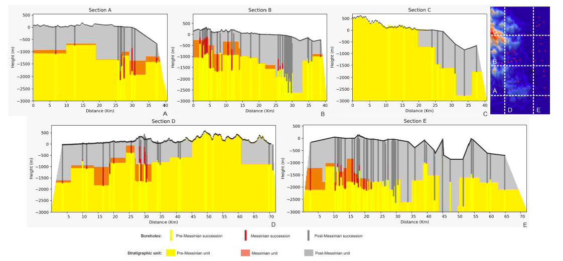
The 3D modeling and representation of geological data have experienced significant growth within last years, due to the use of new technologies derived from advancements in land representation methods. These technologies enable interactive, intuitive and clear geological visualizations. This paper shows how, by using the open-source Python software (operable with a simple internet browser) for machine learning (linear and KNN interpolations), together with Geographic Information Systems (GIS), it is possible to achieve interactive 3D visualizations of geological features in sedimentary basins. This study is performed in the onshore-offshore Crotone area (southern Italy) where a large amount of stratigraphic datasets are available from core perforation and seismic profiles due to the presence of a natural gas extraction field. Thanks to a database of 63 drilling lithologic records and 43 check points obtained from 9 interpreted seismic sections, several 3D HTML models were constructed defining three stratigraphic units (Pre-Messinian, Messinian, and Post-Messinian). An overlap of the Post-Messinian top surface and an erosional truncation of the Messinian top surface toward the N were observed, together with a rising of the Pre-Messinian top surface in the northwestern area. This stratigraphic architecture may indicate differential subsidence and/or uplifting due to syn-sedimentary fault kinematics in the whole studied area. The 3D models with the stratigraphic unit boundary surfaces obtained with KNN interpolation (showing stepped and abrupt edges) allowed the interpretation in terms of structural architecture and synsedimentary fault kinematics. Three main sets of faults were deduced: N–S; NNW-SSE, and ENE-WSW. A minorly represented E-W set was added to the main sets. These faults generated a horsts-grabens structure, and in many cases a determinate set of faults caused a progressive lowering or rising of some areas with an “en echelon” arrangement. According to previous works, these deduced sets of faults (most of them strike-slip faults) have a good agreement with the general structural architecture and defined faults in the area.
Cite as: Falsetta, E., Bullejos, M., Critelli, S. and Martín-Martín M. (2024). 3D modeling of the stratigraphic and structural architecture of the Crotone basin (southern Italy) using machine learning with Python. Marine and Petroleum Geology 164 (2024) 106825. https://doi.org/10.1016/j.marpetgeo.2024.106825
Tags: 3d geological map, Crotone basin, KNN algorithm, Python libraries
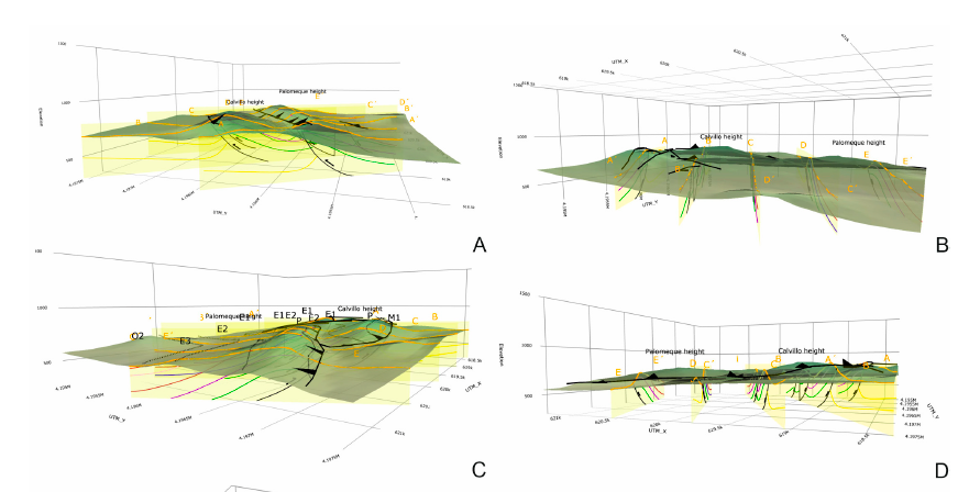
The goal of this paper is the construction of computerized 3D visualization of geological structures. Several Python applications have been used to adapt the paper map-based geological classical information to numerical geological maps represented in HTML files. The models include a map with the stratigraphic and structural contacts and symbols, five serial vertical sections, and a geological block diagram, all with real topography. This block diagram made with 2D figures allows a 3D visualization. Palomeque area (Murcia region, southeastern Spain) has been used as a key-case. This area consists of a deformed Upper Cretaceous to Oligocene succession belonging to the Internal Zone Malaguide Complex. The main structure consists of two thrust-fold sheets forming an imbricate system, also affected by a set of strike-slip faults with a sinistral regime. The constructed maps show a good agreement with the published classical geological maps and cross-sections demonstrating the benefits of using these Python applications.
Cite as: Bullejos, M. and Martín-Martín, M. (2023): 3D Visualization of geological structures using Python: the case study of the Palomeque sheets (SE, Spain). Journal of Maps 19, NO. 1, 2282593 https://doi.org/10.1080/17445647.2023.2282593
Tags: 3d geological map, geological block diagram, Internal Betic Zone, Malaguide Complex, Python applications, thrust-fold sheets
Recent Comments