Home » 2019 (Page 2)
Yearly Archives: 2019
Jiménez de Cisneros tribute in Crevillente
On september 5th of 2019 there will be a field trip (17:30 to 21:00) organized under the summer school course of the University Miguel Hernandez entitled “Jimenez de Cisneros, pioneer in the geological and paleontological investigation in the Southern Alicante”.
More information about the Crevillente course here.
The participant will see the southern section of the Crevillente Sierra from Los Molinos educative center to the Pouet de la Mel spring. Visiting the neogene cover, the Els Pontets diapir, and the Mesozoic carbonatic rocks of the Crevillente Sierra.
The conductor of this field trip will be our collegue José Enrique Tent Manclús.
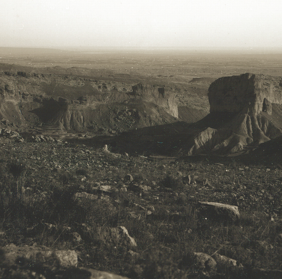
Paleogene sedimentary evolution of the Alicante Trough
A new work to illustrate a changes in the evolution of the Alicante Trough located to the southeastern part of the sudiberian paleomargin and north to the supposed elevated sea floor forming a marine platform. Here the link to the work in Repository of the UA.
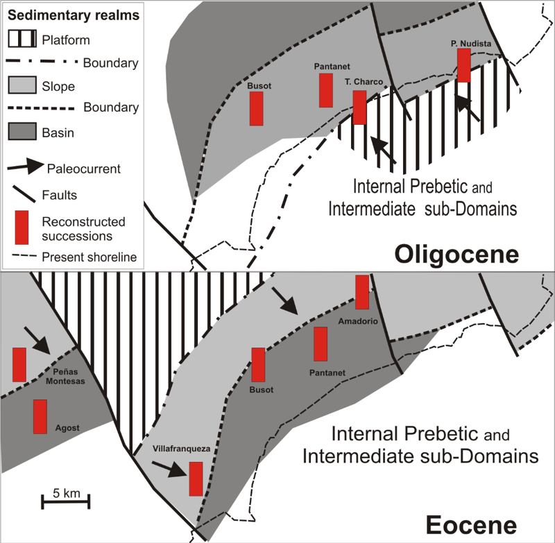
The Paleogene Alicante Trough of the South-Iberian Margin (External Betic Zone) consists of a narrow sedimentary basin that has active margins located to the north-northwest (active mainly during the Eocene) and to the south-southeast (active during the Oligocene). Both margins, consisting of shallow unstable platforms, were the source areas for the external-platform slope (in the opposite margins) and deep-basin (in the middle) depositional realms. The southern margin, lost under the Mediterranean Sea, is recognized only by the reconstructed Oligocene slope sediments.
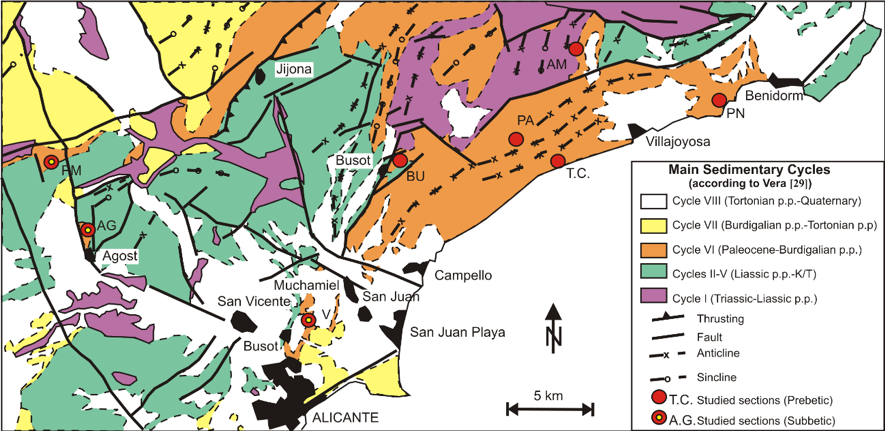
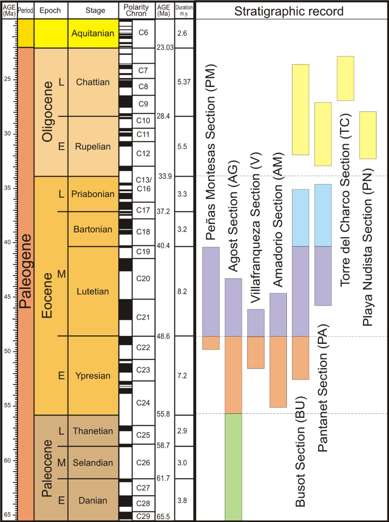
The eight successions studied, on opposites external-platform-slope margins and the deep within the central part of the basin, lead us to divide the basin into two depositional realms: the subsident Western Depositional Area (WDA) and the not subsident Eastern Depositional Area (EDA). This study has also enabled us to divide the infilling of the basin into two depositional sequences: Eocene p.p. (EDS) and Oligocene p.p. (ODS) in age, respectively, bound by two sequence boundaries (unconformities) at the Early Eocene (P6 zone) and Early Oligocene (P19 zone). The EDSand ODSare comprised of turbiditic and olisthostromic deposits and frequently slumps, evidencing an active tectonic in the margin-basin system.

The correlation of the Paleogene sedimentary reconstructed in the Alicante Trough with other four synthetic successions throughout the External (three in the Subbetic Domain) and one in the Internal Betic Zone indicate a Paleogene generalised deformational framework.
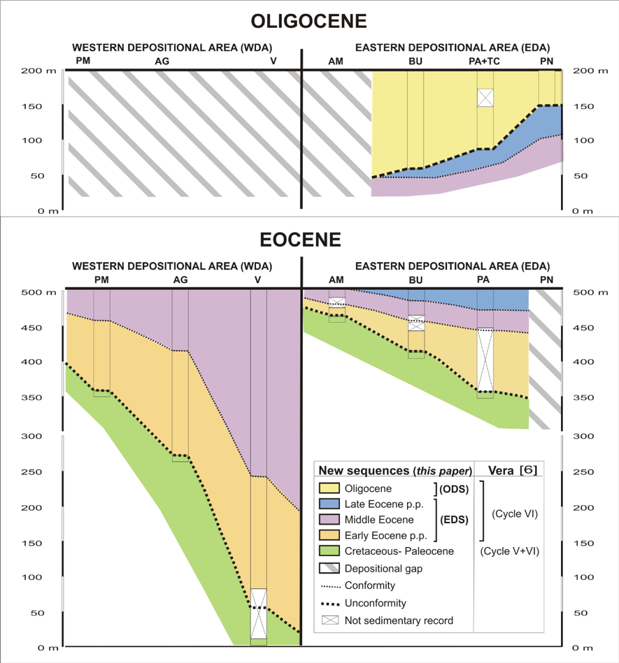
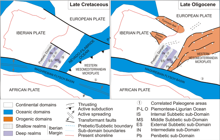
In addition, this evolution is contemporaneous to the Pyrenean, Iberian and the Nevado-Filabride Alpine deformation. The Paleogene tectonic recognised in the External Betic Zone is younger since the main orogenic deformation took place in the late Burdigalian to early Tortonian.
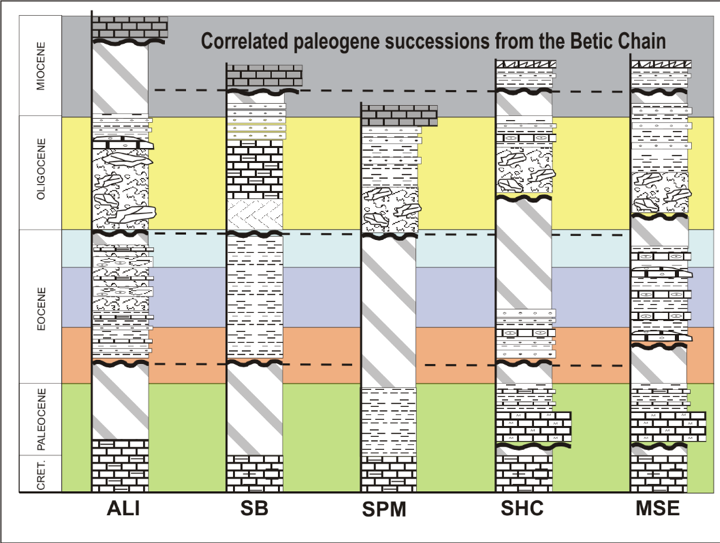
The origin of these early tectonics is discussed in relation to the Nevado-Filabride Alpine deformation.
8th International Brachiopod Congress
The 8th International Brachiopod Congress was held at the University of Milan (Università deli Studi di Milano) and organized by a committee chaired by Lucia Angiolini from Milan and Renato Posenato from Ferrara.
A four-day pre-congress fieldtrip was proposed to Spain with a detailed guidebook published by García Joral et al., (2018). The fieldtrip to Spain started on 6th September 2018 in Madrid, from where participants headed northwards to Aragon, where in the Iberian Ranges two days were devoted to Jurassic and one to the Palaeozoic (Ordovician, Silurian, and Devonian). The last day took the participants to the Betic Mountains near Alicante, where we admired the Liassic faunas of the Mediterranean province.
Pictures of the congress and the fieldtrips can be seen in:
Halamski A. T., 2019. Eighth International Brachiopod Congress Milan, Italy, 11th-14th September, 2018. http://paleopolis.rediris.es/BrachNet/REF/Pub/halamski-2019.html, 9 p

Reference:
García-Joral F., Villas E. & Baeza-Carratalá J.F. (eds), 2018. 8th International Brachiopod Congress Field Guide. E1: Paleozoic and Mesozoic brachiopods of East Spain, ii + 76 pp. Workcenter Servicios Globales de Documentación, Madrid.
Source areas in the Agost Basin (Betic Cordillera)
A new work to illustrate a changes in source areas related with pull-apart basin in the Betics. Here the link to the work in researchgate.
Sedimentary and mineralogical analyses were performed in the Neogene Agost Basin (External Domain, Betic Cordillera) to reconstruct relationships between tectonics and sedimentation, and source areas evolution over time.
Geological Setting
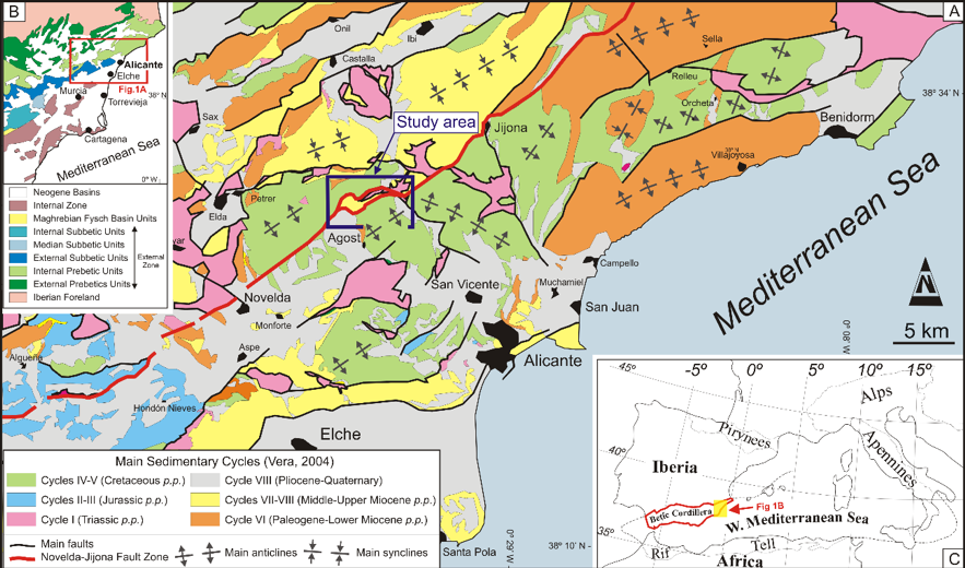
The sedimentary analysis allowed defining two sedimentary sequences: (1) Lower Stratigraphic Unit, Serravallian p.p. and (2) Upper Stratigraphic Unit, post Lower Tortonian (Upper Miocene p.p.)separated by an angular unconformity. They consist of marine (lithofacies L-1to L-3) and continental (lithofacies L-5to L-8) deposits respectively (Figure 2).
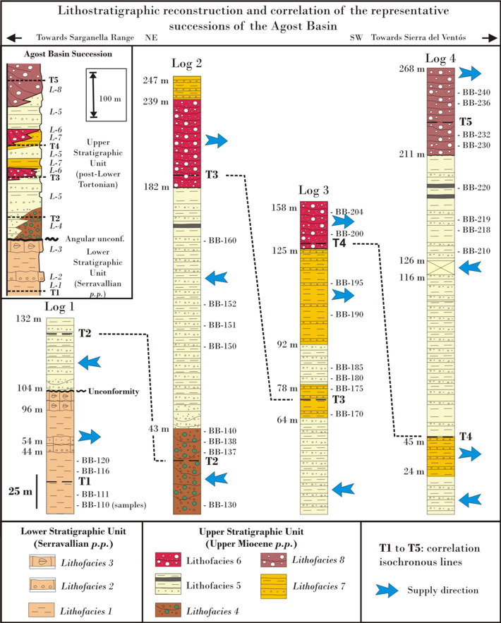
The analysis of mineralogical assemblages and some XRD parameters of the sedimentary sequences (Figure 3) and older formations (Figure 4) allowed recognizing a sedimentary evolution controlled by the activation of different source areas over time.
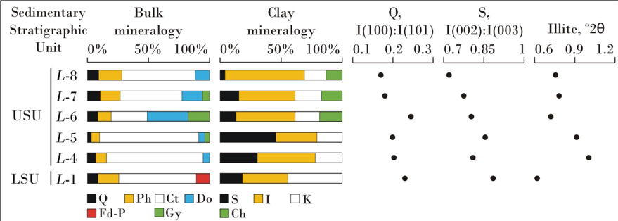

In particular, the Ill+Kln±Sme+Chl clay-mineral association characterizes the supply from Triassic formations; the Ill+Kln+Sme association from Albian formations; the Sme+Ill±Kln+(I-S) and Sme+Ill±Kln associations from Upper Cretaceous p.p.formations; and the Sme+Ill±Kln+(I-S) association from Paleogene formations, testifying a tectonic mobility of the basin margins differentiated over time (Figure 5).
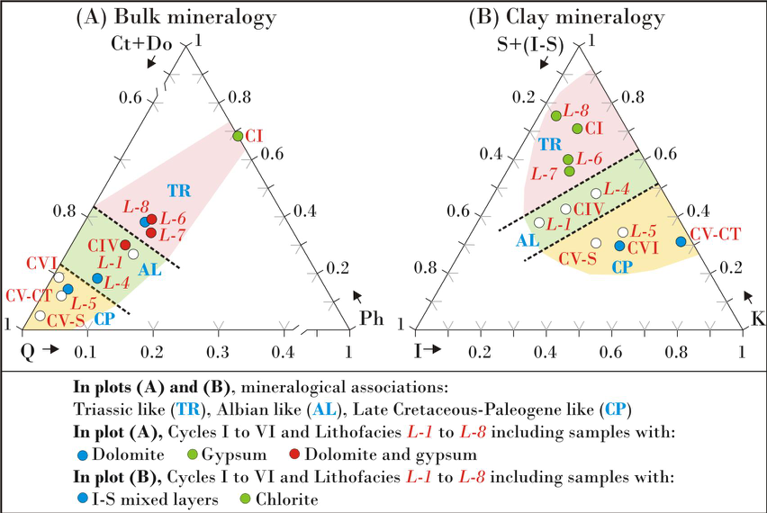
This reconstruction leads to propose detailed relationships between types of deposits and provenance and not a classic “unroofing”, as follows: (i) the lithofacies L-1 (lithofacies L-2 and L-3 were not analysed) is characterized by the Ill+Kln+Sme mineralogical association indicating an origin from the Albian formations; (ii) the lithofacies L-4 shows a mixture of Ill+Kln+Sme and Sme+Ill+Kln associations sourced from the Albian and Upper Cretaceous formations; (iii) the lithofacies L-5 is characterized by the Sme+Ill±Kln+(I-S) association indicating a provenance from the Upper Cretaceous and Paleogene formations; (iv) the lithofacies L-6 to L-8 are characterized by the Ill+Kln±Sme+Chl association indicating a supply mainly from Triassic deposits. The evolutionary sedimentary model reconstructed for the Agost Basin, which improves a previous contribution about the same area, has been correlated with those reported in other intramontane Neogene basins in the Betic-Rifian Arc studied with similar resolution, so obtaining useful information for regional reconstructions.
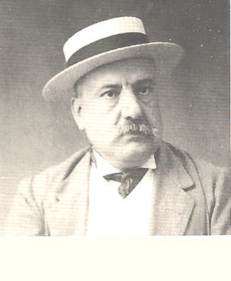
Daniel Jimenez de Cisneros
Next September the village of Crevillente will be organised a summer course inside the offer of the Miguel Hernández University summer course entitled “Jimenez de Cisneros, pioneer in the geological and paleontological investigation in the Southern Alicante”.
Presentation
This year marks the centenary of Daniel Jiménez de Cisneros, Professor of Natural History, publication in the “Iberia” journal, of the first geological and paleontological synthesis of the Crevillente Sierra.
Daniel Jiménez de Cisneros made what could be the first and oldest photographs of the Crevillente Sierra, an exceptional graphic testimony that allows us to see what the landscape of this mountain was like 100 years ago. We also owe him not only the identification of the main paleontological sites of the mountains, but also the approach of the first geological itineraries on it, published in the “Iberia” journal in 1919.
This course makes this figure known to us and brings us closer to the geology and paleontology of our environment by the help of great specialists.
Ana Satorres course coordinador.
More information about the Crevillente course here.
One of the events of this course will be a field trip to the Crevillente Sierra to see the some of the historical sites mentioned in the 100-year-old paper of Jimenez de Cisneros conducted by Jose Enrique Tent- Manclus.
All the news about the event will be comment in this blog.
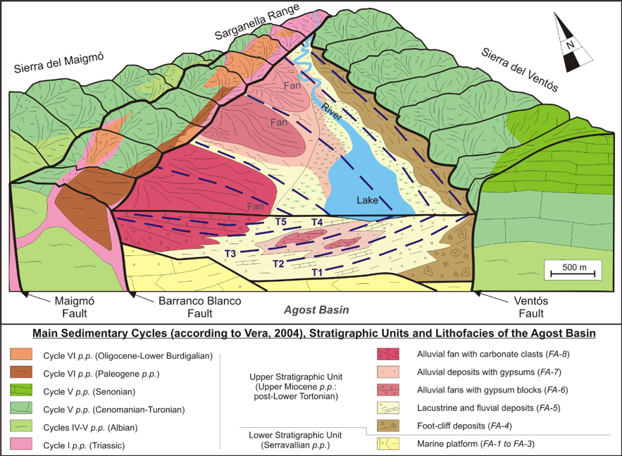
The Agost Basin (Betic Cordillera, Alicante province, Spain): a pull-apart basin involving salt tectonics
A new work to illustrate a strike-slip basin in the Betics. Here the link to the publisher.
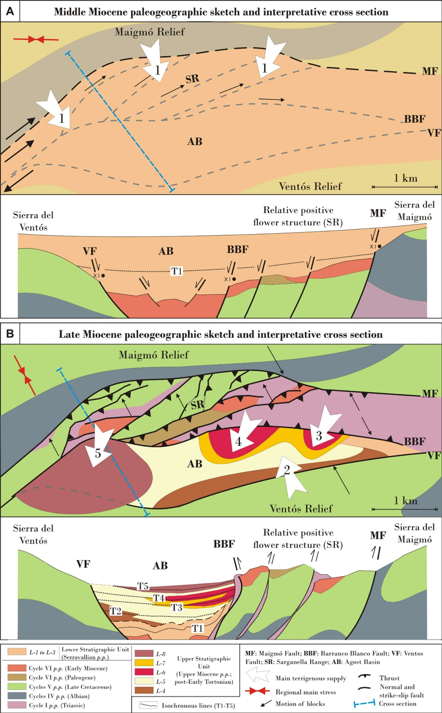
The Agost Basin is characterized by a Miocene-Quaternary shallow marine and continental infilling controlled by the evolution of several curvilinear faults involving salt tectonics derived from Triassic rocks. From the Serravallian on, the area experienced a horizontal maximum compression with a rotation of the maximum stress axis from E-W to N-S.

Geological setting
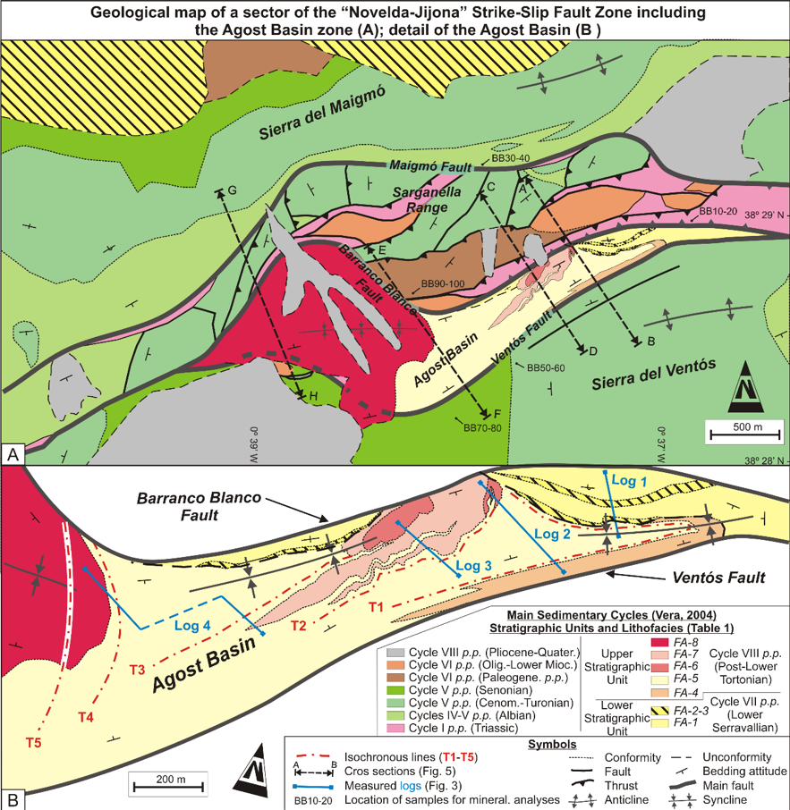
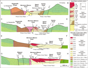
The resulting deformation gave rise to a strike-slip fault whose evolution is characterized progressively by three stages (see Figure 4): (i) stepover/releasing bend with a dextral motion of blocks; (ii) very close to pure horizontal compression; and (iii) restraining bend with a sinistral movement of blocks.
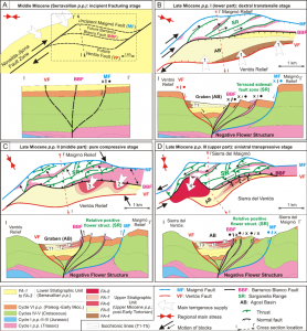
In particular, after an incipient fracturing stage, faults generated a pull-apart basin with terraced sidewall fault and graben subzones developed in the context of a dextral stepover during the lower part of late Miocene p.p. The occurrence of Triassic shales and evaporites played a fundamental role in the tectonic evolution of the study area. The salty material flowed along faults during this stage generating salt walls in root zones and salt push-up structures at the surface. During the purely compressive stage (middle part of late Miocene p.p.) the salt walls were squeezed to form extrusive mushroom-like structures. The large amount of clayish and salty material that surfaced was rapidly eroded and deposited into the basin, generating prograding fan clinoforms. The occurrence of shales and evaporites (both in the margins of the basin and in the proper infilling) favored folding of basin deposits, faulting, and the formation of rising blocks. Later, in the last stage (upper part of late Miocene p.p.), the area was affected by sinistralrestraining conditions and faults must have bent to their current shape. The progressive folding of the basin and deformation of margins changed the supply points and finally caused the end of deposition and the beginning of the current erosive systems. On the basis of the interdisciplinary results, the Agost Basin can be considered a key case of the interference between salt tectonics and the evolution of strike-slip fault zones. The reconstructed model has been compared with several scaled sandbox analogical models and with some natural pull-apart basins.
Research supported by: Research Project CGL2016-75679-P, Spanish Ministry of Education and Science; Research Groups and Projects of the Generalitat Valenciana, Alicante University (CTMA-IGA); Research Group RNM 146, Junta de Andalucía; Grants from University of Urbino “Carlo Bo”, responsible M. Tramontana.
About this blog
This is a geological blog of a team of worker in the Westernmost Tethys which rocks are today found surrounding the Western Mediterranean basin (from the Gibraltar Strait to the Messina Strait-Sicily passage).
We are focus on the interaction of the two main continents of Africa and Europe and the microplates in between.
In this blog will comment our works, highlight the key point, illustrate our fieldwork and add new figures.
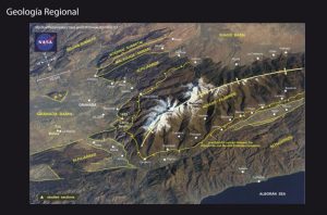
Figure of the Central Betics showing the metamorphic complexes and the neogene basins.
Recent Comments